This is just for a little fun on how my blogging has been for me over the past few months that I have been blogging. I hope you can relate to me in some way like this. If you do, then let me know in the comments. Thank you, and enjoy!


This is just for a little fun on how my blogging has been for me over the past few months that I have been blogging. I hope you can relate to me in some way like this. If you do, then let me know in the comments. Thank you, and enjoy!

Power plants and earthquakes do not mix very well when one happens. Earthquakes are one of the greatest natural disasters to occur any where in the world, especially if it is on the U.S. west coast. Power plants are especially at risk from earthquakes as one would cause large amounts of damage to it. Some power plants, such as solar and wind, would not cause much trouble, but fossil fuel and nuclear would be a major concern as both would cause great harm to the environment around them. We shale explore the risks that these earthquakes have on these power plants and which ones should be paid close attention to.
The United States is overwhelmingly dependent of fossil fuels and nuclear power for almost all of its commercial energy. American power generating plants are at some risk to earthquakes. Some power plants are located perilously close to or along earthquake fault zones. The vulnerability of energy production facilities to an earthquake depends on two factors: the proximity to known fault lines, and the ability of the power plant and its supporting infrastructure to withstand an earthquake, which depends on its design, construction, upkeep and age. Damage to nuclear reactors is of utmost concern to the public. However, damage to large fossil-fuel based plants is also an issue, as their supporting industrial and transportation infrastructure is vulnerable to ground liquefaction.

Most people are familiar with the major earthquake zones associated with Earth’s tectonic plate boundaries from Geology 101, but the real world is much more complicated, and very often, we can underestimate it. This has already happened with the Fukushima nuclear power plant disaster in Japan in 2011. When a 9.0 earthquake struck the island nation, quickly followed by a tsunami, it cause the plant to lose power and unable to control their nuclear reactors.

By the time they did, the damage was already done. Three reactors over heated, explode and released radiation across the island nation for three days. If such an event could happen there in the island nation from across the pacific ocean, then it could potentially happen here in the U.S. as well with a similar and disastrous result.
The U.S. Geological Survey has mapped many other potentially hazardous seismic areas across the country in the past few decades. Many of these zones happen to be in densely populated areas, where the seismic danger was not known when the power plants were built. Human-induced earthquakes are also an issue. The possibility of earthquakes strong enough to damage U.S. power production infrastructure is very real.

In the map provided above, there are a large amount of power plants across the US. Some of them, which are in big groups like in North Carolina and California, are solar and wind, but most of them, which are mostly scattered, are fossil fuels and nuclear. Many of these power plants lie dangerously close to where earthquake faults lie and are thus in earthquake risk zones. Hawaii, being an active volcanic island, does possess some earthquake risk and there are at least four power plants that lie there. In Alaska, many power plants lie across the state, given that Alaska is mostly a power production state, and the plants south of the state are at the greatest risk of earthquakes from the Denali Fault that lie’s there.
In the mainland of the US, there are a series of earthquake faults along the west coast of the country, which gives out a great risk zone for earthquakes. Many power plants lie in many of those risk zones and which some of them are fossil fuels and nuclear. There is also a risk in the central area where many power plants lie. That area is actually where the New Madrid fault lies and it provides great risk for the power plants in that area as well. There is also a small risk area in South Carolina as well. This area actually had an earthquake occur in 1886 that had a magnitude of 6.9-7.3 and caused great damage in the area. If that were to happen again, then there would be some risk there for the power plants in the area.

Earthquakes are a great danger that no one is to underestimate when one does happen. Power plants in the US have to make sure that they are safe from earthquakes, such as being in areas where there is the least amount of risk and making sure they are stable enough to resist an earthquake, especially the fossil fuel and nuclear power plants. If one or the other are to be damaged in any way from an earthquake, it would affect the environment around the area for generations to come. This is why we must ensure the safety of the power plants that are closest to earthquake risk zones, so that they would stay safe and keep the power flowing, as well as keeping the environment protected. The risk of earthquakes to power plants is real, and we must take the careful steps needed to keep them safe and stable enough to ensure that we can live our lives as safely as we can be.
Sources Used:
https://www.arcgis.com/home/index.html
Petersen, M. et al., 2018 One-Year Seismic Hazard Forecast for the Central and Eastern United States from Induced and Natural Earthquakes – Seis. Res. Lett., doi.org/10.1785/0220180005.
https://www.climatecentral.org/news/natural-gas-to-surpass-coal-for-electricity-20154
https://www.worldatlas.com/articles/the-largest-coal-power-stations-in-the-united-states.html
https://www.latimes.com/local/lanow/la-me-ln-california-mexico-earthquake-20170908-htmlstory.html
https://spectrum.ieee.org/static/fukushima-and-the-future-of-nuclear-power
http://time.com/5388178/japan-first-fukushima-radiation-death/
The word ‘CAJUN’ is derived from the French word ‘ACADIAN.’ The word ‘Acadian’ describes the 17th and 18th Century people from an area of Canada called Arcadia or Arcadie. The popular meaning for the word ‘Acadie’ is ‘earthly paradise,’ from the language of the Micmac Indians, who inhabited the area at the time. Usually, the word Cajun is used to describe those French people from south Louisiana. But the term Acadian is sometimes used; and when one looks into it, they find that their ancestors in fact were Acadians from Canada. Acadians and Cajuns are the same, yet they are different. We will explore the history behind the two words and how they compare to each other.
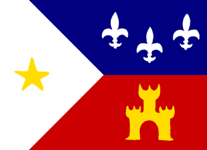
The word “Cajun” did not come into being until sometime in the late 18th Century and is strictly a South Louisiana word. Up to World War II the word “Cajun” was somewhat of a source of embarrassment and ridicule. This came about because it suggested “a poor and uneducated person who spoke mostly French and some, if any, broken English.” It was not until the late 1940’s and early 1950’s that the Cajun population realized that this negative attitude was causing the eradication of their culture and the lost (sic) of their identity as an ethnic group. Through the efforts of many concerned people and organizations, a movement was designed to turn the negativism (sic) around into positive thinking and encourage proud feelings about the history and culture of their ancestors and the preservation of their French language. The heart of the Cajun culture is its language. This is on-going.
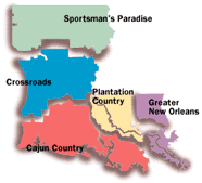
The 22 parishes designated by the Louisiana congress as “Cajun Country” is also known as Acadiana. There’s a great story behind how the term Acadiana was coined. The Acadians were French settlers who settled the area (now known as Nova Scotia) in the 1600’s. In the mid 18th century, they were exiled by the British. Over the following 30 years, several thousand of the exiled Acadians made their way to south Louisiana. Over the next 100+ years, the Acadians became the dominant culture in certain areas of south Louisiana. They retained much of their culture, and absorbed some of the other cultural influences. The German, Spanish, French, English, Indian and other cultures added to the Acadian culture to produce the Cajun culture. The word “Cajun” comes from the word “Acadian”, just as “Injun” is a variant of the word “Indian.” So, the Acadians were French settlers in 17th-18th century Canada. When they were exiled, they were no longer a single group. But the Acadian people survived in other cultures, sometimes merging into those cultures, and sometimes (as in south Louisiana) being a dominant culture. Today’s Cajuns may have roots that go back to the Acadians. But along the way, you will probably find German, French, Spanish, etc. ancestors that merged with the Acadians.

Cajun and Acadain means a lot when together and define a people for who they are. These people have a culture and a way of life as well that we have not explored into very much, but these people are very unique in their own way. They have a special french like language, spicy foods, an arrange of festivals, special arts, fun music and humorous content as well. They are an interesting people that should be worth a look into further. Cajun and Acadain are terms that tell us of a group of people that have their own way of life, and they should be recognized for what they are and how they are defined by it.
Sources Used:
https://www.louisianatravel.com/articles/10-cajun-essentials-guide-cajun-culture-louisiana
Heritage

The Four Corners refers to a location where four states of the United States meet. These corners include the states of Colorado, New Mexico, Utah, and Arizona. The Four Corners is the only unique landmark in the United States where four states actually intersect at one geographic point. A tourism destination by itself or a perfect addition to Arches and Canyon-lands itineraries, Four Corners is a spiritual journal into sweeping landscapes with profound human and geologic history. We will explore what the history of these four corners and why they are so symbolic in the region.
The Four Corner region was part of Mexico until 1848 when the Mexican-American war came to an end and the region ceded by Mexico. In 1861 the Congress established the territory of Colorado, and in 1863 it created the territory of Arizona from the western part of New Mexico Territory. The boundary between the two territories was defined as a line south of the southwest corner of Colorado Territory. Congress had earlier demarcated territorial boundaries using longitude and latitude lines or physical features such as a river, but in this instance, it sought to establish a point at which four territories would converge regardless of survey errors that were likely to occur during the demarcation process. In 1868, the government began surveying the territories with the aim of establishing Colorado as a state. Colorado became the first of the four territories to be declared a state. On January 4, 1896, Utah became the second territory to be declared a state. On January 06, 1912, New Mexico became a state, and on February 14, 1912, Arizona became the last of the four states to be admitted.

Following government surveys that revealed a terminus of the Four Corners states’ boundaries joining in one place, surveyors erected the original Four Corners Monument in 1912 as a simple cement pad. In 1992, the monument evolved to a copper disc within a granite surface and 2010 brought new improvements. Two intersecting lines through the center of this disc mark the boundaries, accompanied by the seal of each of the Four Corners states. The Navajo Nation Parks and Recreation Department administers the Four Corners. Around the monument, Native American artisans and craftsman sell their handmade jewelry, crafts and traditional foods from numerous booths and shops. The monument’s visitor venter features information about the native cultures of the region.

The convergence of the four states led to the rise of the region, but the accuracy of the monument has always been doubtful. Initially, the surveyors were required to follow the latitudes and longitudes, but they instead placed markers that that did not tally with the points. In 1919 and 1925, border claims led to a court case between New Mexico and Colorado but the Supreme court ruled that the boundaries would remain as placed by the markers. In 2009 the boundary issue found its way to the Congress after the media stated that it had been placed 2.5 miles from the correct location. The matter as used to rest when US National Geodetic Survey state that the surveyors had used the Washington meridian and not the Prime Meridian as the reference point. After modern survey equipment was used to locate the exact boundary, it was determined that the monument lies 1,807 feet from where present day surveyors would place it. However, the US National Geodetic Survey, the Supreme Court, and the Navajo governments agree that the surveyors did exemplary work given the survey technology at their disposal. The boundary was thus upheld.
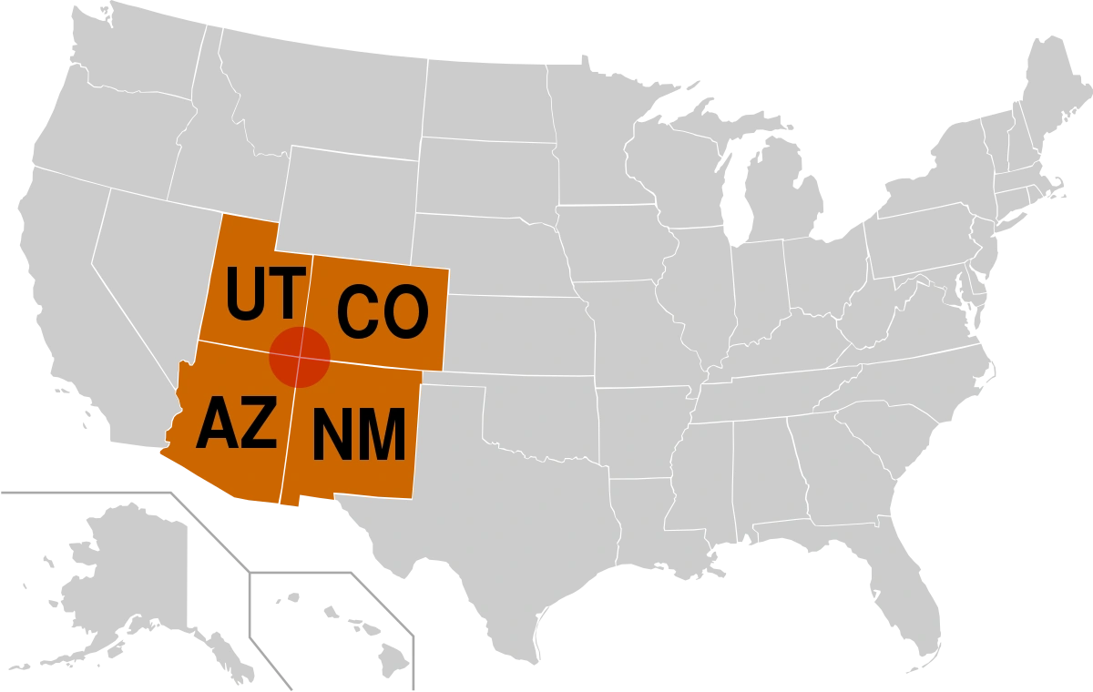
The Four Corners of the United States marks the only place in the United States where the corners of four states actually meet in one place. This is very significant as no where else in the United States is where this particular geographical feature happens. It is also significant as this defines the states that formed the country as we see it today. It also tells the tale of the Native Americans in that region and the history that went in behind the formation of these states that we know them as now. These four corners of the four western states are more significant than what people take credit for, which is why people must recognize just how important this region of land is and the history that went into it as it defines the western part of the United States that we know of it to this day.
Sources used:
https://historica.fandom.com/wiki/Four_Corners
Four Corners Monument
https://www.visitutah.com/places-to-go/parks-outdoors/four-corners-area/
https://www.worldatlas.com/articles/where-is-the-four-corners-region-in-the-united-states.html
https://voyagenation.com/en/amp/Four-Corners-Monument/Cortez/Colorado
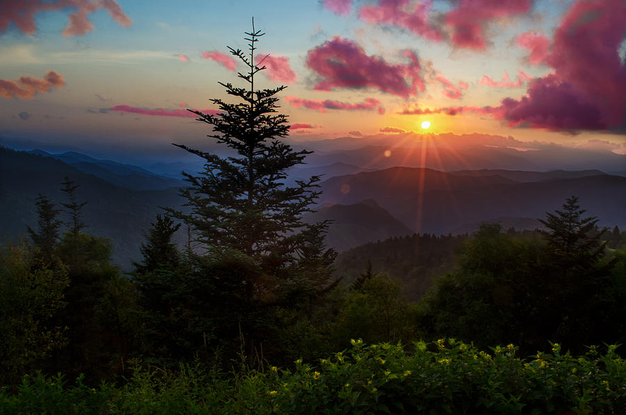
We end this series with this last image here which shows a great sunset in the Smoky Mountains, which is a very grand scene to end this series. Science Daily details science behind these striking sunsets and the phenomenon of scattering. Tiny molecules change the direction of light rays in the atmosphere, causing them to scatter. When the sun is low on the horizon at sunset, sunlight passes through more air. Blue and violet are short-wavelengths and are scattered much more than other colors on the spectrum. That is why we see a blue sky during the day when the sun is high. When there is more atmosphere, that means there are more molecules to scatter the violet and blue light away from your eyes. Because red has the longest wavelength of any visible light, the sun is red when it’s on the horizon. This also explains why sunsets tend to exhibit colors of yellow, red, and orange. The details of the sunset are determined by the wavelength of the light and the size of the particle.
According to National Geographic, you may see more vibrant sunsets based on the seasons. In the east, the fall and winter create marvelous sunsets because the air tends to be dryer and cleaner for the path of sunlight. Pollution also tends to mute and muddy the colors of sunsets because large particles in the lower atmosphere tend to have that effect. In places where there is a lot of haze, it is less common to observe dramatic colors.
In this final image, the sun is setting beautifully upon the mountain hill-tops of the Smoky Mountains in North Carolina. This image was taken by Christopher Mobley who uploaded it on the 31st of July, 2012, and it show the stunning scene of the sun falling into the distance to beyond the horizon of the Smoky Mountains. A truly perfect end of the Power of Nature series with this scene of the adventure coming to an end here as the day there draws itself to a close.
Sources Used:
https://medium.com/engl462/why-are-some-sunsets-more-colorful-than-others-ade6e482b062
https://pixels.com/featured/smoky-mountain-sunset-christopher-mobley.html

For this next image, we move back down to Earth and head to downtown Raleigh, where a winter storm is happening. Winter storms derive their energy from the clash of two air masses of different temperatures and moisture levels. Winter storms usually form when an air mass of cold, dry, Canadian air moves south and interacts with a warm, moist air mass moving north from the Gulf of Mexico. The point where these two air masses meet is called a front. If cold air advances and pushes away the warm air, it forms a cold front. When warm air advances, it rides up over the denser, cold air mass to form a warm front. If neither air mass advances, it forms a stationary front.
The snow itself is commonly formed when water vapor undergoes deposition, which is when water vapor changes directly to ice without first becoming a liquid, high in the atmosphere at a temperature of less than 32°F and then falls to the ground. The winter storm itself is identified as an ice storm, which is a type of winter storm caused by freezing rain. The U.S. National Weather Service defines an ice storm as a storm which results in the accumulation of at least 0.25-inch of ice on exposed surfaces. It forms when a layer of warm air is between two layers of cold air. Frozen precipitation melts while falling into the warm air layer, and then proceeds to refreeze in the cold layer above the ground. This creates freezing rain or a glaze of ice.
The picture that is taken here shows an ice storm happening in the city of Raleigh, North Carolina on the 23rd of January, 2016. We see ice and snow on the roads, trees and on the ground near where the city skylines are located. There are very few cars on the road as the ice makes them slippery and not everyone would be driving on such roads with this much ice on them. Ice storms can be very hazardous when people are driving on the roads.
Sources Used:
http://www.weatherwizkids.com/weather-winter-storms.htm
http://raleighskyline.com/content/2016/01/23/raleigh-snow-and-ice-storm-january-22-23-2016/
The next satellite image that will be looked into in this series will be that of a hurricane. Just like how mid-latitude cyclones are not hurricanes, hurricanes are not mid-latitude cyclones like the one in the previous image. Hurricanes are the most violent storms on Earth. People call these storms by other names, such as typhoons or cyclones, depending on where they occur. The scientific term for all these storms is tropical cyclone. Only tropical cyclones that form over the Atlantic Ocean or eastern Pacific Ocean are called “hurricanes.” Whatever they are called, tropical cyclones all form the same way.
Tropical cyclones are like giant engines that use warm, moist air as fuel. That is why they form only over warm ocean waters near the equator. The warm, moist air over the ocean rises upward from near the surface. Because this air moves up and away from the surface, there is an area of lower air pressure below. Air from surrounding areas with higher air pressure pushes in to the low pressure area. Then that “new” air becomes warm and moist and rises, too. As the warm air continues to rise, the surrounding air swirls in to take its place. As the warmed, moist air rises and cools off, the water in the air forms clouds. The whole system of clouds and wind spins and grows, fed by the ocean’s heat and water evaporating from the surface. Storms that form north of the equator spin counterclockwise. Storms south of the equator spin clockwise. This difference is because of Earth’s rotation on its axis. As the storm system rotates faster and faster, an eye forms in the center. It is very calm and clear in the eye, with very low air pressure. Higher pressure air from above flows down into the eye.
When the winds in the rotating storm reach 39 mph, the storm is called a “tropical storm.” And when the wind speeds reach 74 mph, the storm is officially a “tropical cyclone,” or hurricane. Tropical cyclones usually weaken when they hit land, because they are no longer being “fed” by the energy from the warm ocean waters. However, they often move far inland, dumping many inches of rain and causing lots of wind damage before they die out completely.
The image above is a satellite image of Hurricane Florence from 2018 that was taken by NASA’s astronaut Ricky Arnold from the International Space Station on Sept. 10, as it heads toward the U.S. East Coast. Classified as a category 4 storm, with wind speeds up to 130-156 mph, it is one of the most powerful storms to strike the U.S. east coast, causing large amounts of damage to the region and much property loss. Some people are still struggling after the hurricane has long since passed.
Sources Used:
https://spaceplace.nasa.gov/hurricanes/en/
https://slate.com/news-and-politics/2018/09/hurricane-florence-projected-path-impact-category.html
In addition to some images on the ground there will also be so images in space as well, as satellite imagery can capture some remarkable weather events that are happening on Earth from the area of space. For this case, we are looking at a mid-latitude cyclone that is moving over the Great Lakes of in the United States in North America. Also, just to get this out of the way now and so that there is no confusion, mid-latitude cyclones are not a hurricanes. That will be a topic to talk about in the next image.
Mid-latitude cyclones drive most of the stormy weather in the continental United States. Development of these cyclones often involves a warm front from the south meeting a cold front from the north. In the Northern Hemisphere, cyclones move in a counterclockwise direction. (In the Southern Hemisphere, cyclones are clockwise.) The bands of cold and warm air wrap around a center of low pressure, and air rising near the center spurs the development clouds and precipitation.
The image displayed above is a mid-latitude cyclone in the Midwestern United States that was taken by the Moderate Resolution Imaging Spectroradiometer (MODIS) on NASA’s Aqua satellite at 3:05 p.m. Eastern Daylight Time on September 26, 2011. The center of the storm appeared immediately west of Lake Michigan. The Capital Weather Gang at The Washington Post reported that the storm was at its most mature stage on September 26. Sporting a comma shape spanning hundreds of kilometers, the storm was comprised of a combination of warm, moist air (clouds) and cold, dry air (cloud-free areas).
Sources used:
https://earthobservatory.nasa.gov/images/52297/mid-latitude-cyclone-over-the-united-states
Weather is very important to the sport of baseball more so then one would think. Many people think that weather would determine if the conditions were good to actually play the game or not and nothing more than that, but actually, it is not exactly like that at all. Weather actually has an important influence on the sport as to how a game is played in such conditions and how a baseball travels when it is hit. Air pressure, wind, temperature and humidity are important to note. This will discuss on what factors of weather that has an affect on a game in baseball.
First, we will talk about what rain can do in a game. If rain is heavy enough, the umpire can call for a rain delay and then continue the game later once the rain reduces in intensity or ends. The rain though may not quite be heavy enough to delay the game. Rain can produce problems such as getting a good grip on the baseball, having good traction when running the bases and can interfere with seeing and throwing the baseball as well. To counteract these issues a tarp will be placed on the dirt infield portion of the field during rain. A substance that is highly absorbent can also be placed on the dirt portions of the field such as on the pitching mound and in the base running areas to increase traction and reduce the buildup of mud on cleats. Rain can make the grass areas of the field slippery and players can adapt to this by wearing the proper cleats.

Next off is Wind, the most influential of the weather factors.The wind can have a profound influence on a game. In a game, wind can cause the baseball to change course by many feet. Home-runs are much easier when the wind is blowing out as opposed to blowing in. Windy conditions can make the ball more difficult to catch. Wind can make the ball more difficult to field and throw accurately. Windy conditions generally make the game more difficult to play accurately for all players involved. Players can adjust to this by factoring in wind speed and direction as they go after a ball in the air. This is because wind can either amplify or reduce the amount of friction the baseball experiences during flight. Air flowing toward the baseball in flight acts as a force to slow the forward motion. This slows the ball down and reduces its flight path. Wind flowing with the baseball helps it fly longer distances.

Aside from wind, that plays a factor in how the baseball flies when it is hit, air pressure also plays a factor in this field. Air pressure depends on the elevation of a region and the current weather. Air pressure is usually the most important factor in determining how far a baseball will travel in the air when hit, all else being equal. At higher elevations, air has a lower density. When the air density is lower, baseballs can travel further. Air rubbing against a baseball produces a frictional force. The lower the air density, the smaller this frictional force becomes. Air density also changes depending on whether high pressure or low pressure weather is influencing the region.
Temperature can have a great affect on baseball both physically and scientifically. Very hot temperatures can make the game more difficult to play, especially for the pitcher. The pitcher may not be able to throw as many pitches during a hot game. Hot weather can lead to general fatigue for all players thus it is important to drink plenty of fluids. Very cold weather is even more difficult than hot weather. Cold weather can reduce flexibility, decrease reaction time and decrease concentration. Players can counteract this by wearing an extra layer of clothing and warming up in the dugout between innings. Extreme cold is made much worse when it is combined with other factors such as wind and precipitation. Also, in terms of science, temperature can affect the balls flight. When air warms, it expands. This warming and expansion lowers the density of the air. This produces longer flight distances, all else being basically equal.
The sun, believe it or not, also affects how the game is played, especially on the players. The sun in the eyes is the bane of all baseball players trying the catch a ball. Losing the ball in the sun even for an instance can mean the difference between catching and not catching the ball. To counteract this, players (especially outfielders) will wear sun glasses. The caps also help shade the sun. Eye black can be placed under the eyes to decrease the intensity of the sun glare. The stadium lights can also create a similar effect such as when the ball comes from a similar path that the stadium lights are shining toward a player.
The final weather factor that affects baseball is humidity. At the same temperature, air with a higher dewpoint will be less dense. Click here for an explanation of why this is. At a higher humidity, baseballs will travel a little further, all else being equal.

With all of these weather factors in mind, in order to achieve the optimum for long baseball hits would be to have a high elevation, wind blowing out, warm and humid air mass and to get a minimization for long baseball hits, you would have to have a low elevation, wind blowing in, cold and dry air mass. Baseball is a sport that weather has an important tie with. When games are played with indoor stadiums, it has no affect, but when it is outside, it is a different matter. Weather can affect the outcome of the game and decide where the game will take us to reach that outcome. Knowledge of the weather and how it will affect the game can go a long way to enjoy a game when ever they shout out: “PLAY BALL!”
Sources Found:
https://www.education.com/science-fair/article/affect-wind-baseball-game/
http://www3.allaroundphilly.com/blogs/delcotimes/cvito/2008/04/postponements-in-store.html
https://blog.weatherops.com/that-thin-line-on-radar-is-important

Moving on from lightning, we go on to the most popular weather event ever known to man in North America, especially in the United States, the tornado. Tornadoes are vertical funnels of rapidly spinning air, with winds that may top off to 250 miles an hour and can clear a pathway a mile wide and 50 miles long. These tornadoes, also known as twisters, are born in thunderstorms and are often accompanied by hail. These violent storms occur around the world, but the United States is a major hot-spot with about a thousand tornadoes every year, especially in a region that includes the area’s in the eastern states of South Dakota, Nebraska, Kansas, Oklahoma, northern Texas, and eastern Colorado being home to the most powerful and destructive of these storms. U.S. with tornadoes cause 80 deaths and more than 1,500 injuries per year. This region has come to be known as Tornado Alley.
A tornado forms when changes in wind speed and direction create a horizontal spinning effect within a storm cell, which is then tipped vertical by rising air moving up through the thunderclouds. The meteorological factors that drive tornadoes make them more likely at some times than at others. They occur more often in late afternoon, when thunderstorms are common, and are more prevalent in spring and summer. However, tornadoes can and do form at any time of the day and year. Tornadoes’ distinctive funnel clouds are actually transparent. They become visible when water droplets pulled from a storm’s moist air condense or when dust and debris are taken up.
The image above was taken by a storm chaser on November 7, 2011, America’s deadliest year for tornadoes, with more lives lost and more tornadoes happening than ever before. Yet there are some people that take a great interest in tornadoes and chase them for research, analysis and to take images of them, as well as to prepare people for them should they happen in their area. These people are known as storm chasers and they spend their time chasing tornadoes all across Tornado Alley to collect data and get shots of one. One of these storm chasers caught this image as it moved west of Manitou, Oklahoma. This stunning image of such an incredible storm gives it a place in this series and can sometimes be worth a look for many people to see.
Sources Found:
https://www.nationalgeographic.com/environment/natural-disasters/tornadoes/
https://www.noaa.gov/photo-story-americas-deadliest-year-for-tornadoes-2011
. . . . . . . . . . . . . . . . . FIXING MOUNT RUSHMORE
positive awareness for the betterment of our Earth
To capture, analyze, and to present spatial, and geographic data
A Tarheel's Adventure
Geological, Geographical, Environmental issues and subjects taking place in North America
Geo-life
North American Landscapes & Culture
An Educational Blog
Geography Education and Exploration!
A daily selection of the best content published on WordPress, collected for you by humans who love to read.
Geography Education and Exploration!
Longreads : The best longform stories on the web
The latest news on WordPress.com and the WordPress community.
