Five Themes of Geography and a Walk Through Yellowstone

Five Themes of Geography                Location   HumanEnvironment                Regions Interaction               Geogr...
https://www.slideshare.net/myako1/five-themes-of-geography-lecture

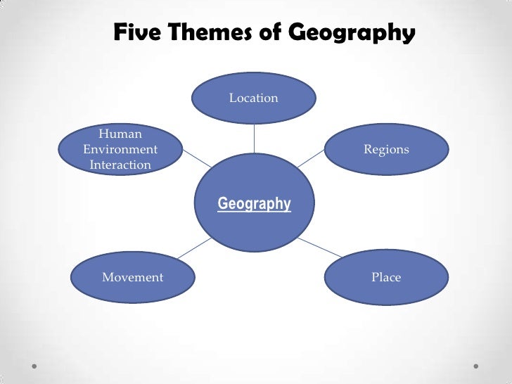
     The five themes of geography are what describe the whole subject of Geography in five themes. They are Known to be location, place, human-environment interaction, movement, and region. When we are discussing the study of the physical features of the earth, including how humans affect the earth and are affected by it, these themes are what we use to describe on how Geography is used. It can be key when we wish to understand a specific area and what we would do to it. To see just how much these themes work in geography, let us look at an example of this in the flagship of the National Park Service and a favorite place to visit for to millions of visitors each year, Yellowstone National Park.

Map Location of Yellowstone National Park
Map shows the location of Yellowstone National Park in the United States.
Yellowstone Road Map
Map of the park shows dimensions of park.
     The first theme is location. It is defined as a particular place or position. Most studies of geography begin with the mention of this theme of geography. Location can be of two types: absolute location and relative location. In the former case, the location of a place is defined by its latitude and longitude. When looking at Yellowstone, we would look at the absolute location of the park when we say its coordinates are 44.4280° N, 110.5885° W. However, when we say that Yellowstone is located mostly in Wyoming while partly being in Idaho and Montana, we are referring to the relative location of the park.

Yellowstone National Park: Unique Places around the World
The “Old Faithful” geyser at Yellowstone National Park erupts in intervals as short as 30 minutes, and no longer than every two hours.

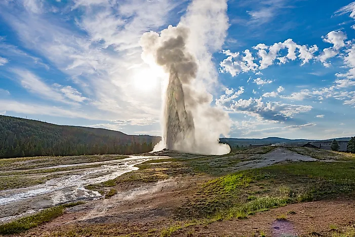
      The next them to talk about is place. This refers to the physical and human aspects of a location. This theme of geography is associated with the name of a place (toponym), the description of the features of the place (site), and the environmental conditions of the place (situation). In Yellowstone, it is described as a geological smoking gun that illustrates how violent the Earth can be. It stands out from other national parks with the extravaganza of its geysers and hot springs, as well as the amount of wildlife that it has with its bison, elk, and bears. The reasons for the geysers and hot springs is due to most of the park rests atop a slumbering super volcano that erupted half a million years ago and is showing signs of renewed activity. Don’t worry, it is not expected to erupt in the near future.

Picture
Land use in Yellowstone.
      This next them focuses on human-environment interaction, as no other species that has lived on our planet, as per our knowledge to this date, has such a profound effect on the environment as humans. Humans have adapted to the environment in ways that have allowed them to dominate all other species on Earth. Humans have also achieved what no other species have been capable of doing: modifying the planet to attain their goals of living. Thus, human-environment interaction needs special emphasis and has been classified as one of the five themes of geography.

Picture
Car driving through Yellowstone.
     Unfortunately, human activity can have many negative effects on Yellowstone’s ecosystem. This would include a rapid spread of disease to Yellowstone’s wildlife, littering, the use of vehicles in the park that can affect air quality, burning of fossil fuels, the use of artificial fertilizers, and sewage dumping. As a result, Yellowstone could undergo a series of changes in the future due to climate change, land use, and invasive species. These factors could dramatically alter the land within the park. Currently, the climate is being monitored around the world. Biologists are taking note of the effects of climate change on ecosystems. In Yellowstone National Park, scientist focus on natural resource monitoring in order to evaluate trends in park resources and status.
     Land use is continually studied to gain information concerning climate change, wildfires, and management of migratory wildlife. Scientist study land use and land cover to understand past, current, and future trend that may affect resources in Yellowstone.

Picture
Photo showing the effects of the disease in the grizzly bear.

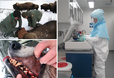
     Biologists studying Yellowstone have noted that human intervention in natural ecological processes may be the cause of wildlife disease and mortality. Human activity has caused many diseases to spread into Greater Yellowstone and has resulted in population declines. The most notable is the population decline of wolves and trout. Management interventions have been put in place to combat the spread of foreign disease in such intricate and delicate ecosystems.

Image result for yellowstone volcano
And Yellowstone’s eruption could happen with less warning than previously thought.
     Many are concerned by the volcanic activity in Yellowstone National Park.Past eruptions have blanketed parts of North America with ash and debris. If another large eruption took place, similar events could occur. Yellowstone National Park is also home to a many active faults, which is a significant earthquake hazard.

Picture
Yellowstone River
     As for the immediate future, there is little evidence for alteration of the Yellowstone ecosystem. Current evidence shows that Yellowstone will continue to survive and flourish. However, we should still continue to protect our environment and allow for Yellowstone to remain intact for many years to come.

Image result for yellowstone wolves
Wolf in the wildlife of Yellowstone.

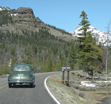
     The Earth is full of movement and in a human-dominated planet, movement primarily refers to the translocation of human beings, their goods, and their ideas from one end of the planet to another. An example of this in our case with Yellowstone is with wolves. In 1995, Yellowstone brought the wolves back to the park. After 70 years without wolves, the reintroduction caused unanticipated change in Yellowstone’s ecosystem and even its physical geography. In a way that improved the park in the years since and made it better than it was before the wolves came back. Another example is the number of people who visit the park and interact with it in their own way. Yellowstone receives about a half-million visitors each year who move in and out of the park to witness the wonders the park provides. This is yet another example of the theme of movement in progress.
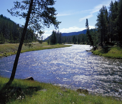
     Finally, we get to region. An area on the planet that is composed of places with a unifying characteristic is a region, one of the five themes of geography. A region is defined by its uniform physical or human characteristics. Yellowstone National Park is in the northwest region of the United States. The park covers 3,472 square miles and is the oldest, one of the largest, and probably the best-known national park in the United States, being established by the U.S. Congress on March 1, 1872 as the country’s first national park. Including the greatest concentration of hydro thermal features in the world, it is home to geysers, hot springs, mud pots and fumaroles bubble, gurgle, hiss and spout throughout the area. The presence of so many thermal features and earth tremors indicates that molten rock lies just beneath the Earth’s surface.

Image result for yellowstone
Girl looking at waterfall in Yellowstone National Park.
     With all of this information, we get a very good idea on what Yellowstone National Park is like geographically. It is America’s first national park with unique water features and great wildlife that rests on a super volcano that is watched over carefully and maintained by the people who observe and protect it. Using the five themes of geography, we are able to determine that Yellowstone is all of this and is recognized as a popular attraction to many people from across the world. Geography is a very grand area of science as it helps us understand the landscape that we have come to know about. These five themes are important to understanding geography, so that we can better understand the world around us for everything that it is.

Witness the true beauty of Yellowstone National Park with a scene of Old Faithful erupting before you!

Sources Used:

https://www.yellowstonenationalpark.com/

https://www.travelwyoming.com/national-parks-and-monuments/yellowstone

http://montanauntamed.com/get-outside/article_410f4e02-ecc0-5202-9107-fa286bb6be33.html

https://www.travelandleisure.com/travel-tips/travel-warnings/yellowstone-supervolcano-eruption

https://visityellowstonenationalparkyall.weebly.com/human-impact-and-the-future.html

https://www.nationalgeographic.com/travel/national-parks/yellowstone-national-park/

https://www.worldatlas.com/articles/yellowstone-national-park-unique-places-around-the-world.html

https://www.yellowstonepark.com/park/where-is-yellowstone-national-park

https://www.worldatlas.com/the-five-themes-in-geography.html

Gentrification – Does it Help or Hurt?

     In order to understand why gentrification is an issue in North America, we must first understand what it is first. Gentrification is the process of renovating and improving a house or district so that it conforms to middle-class taste. This would mean that if an area were to change, it would be improved for the purpose of fitting the middle-class needs. However, this does have some issues to the urban and/or regional places in North America. We shale have a look at what these issues are and why it is such a big deal in North America for our exploration into human geography.

A study finds that gentrification improves Philadelphia neighborhoods, but its ripple effects hurt the most vulnerable.
     To its opponents, gentrification amounts to the colonization of poor, minority neighborhoods by rich people. For others, gentrification is little more than a natural process of neighborhood transformation and change. In reality, gentrification is more complex than we like to think. A study shows that gentrification ultimately hits hard at the least advantaged and most economically vulnerable. Even though the most vulnerable residents are not any more likely than others to leave gentrifying neighborhoods, when they do move they are much more likely to end up in lower-income neighborhoods with more crime and worse schools.
     Even if the economic disparities aren’t as severe as they may seem, a lingering complaint about gentrification is that it destroys the “soul” of a neighborhood. The gritty character, ethnic diversity and eclectic spirit that attracted the initial urban pioneers is overtaken by chain stores, overpriced brunch menus, iPad-tapping hipsters and stroller parking at the corner bar. Those are the kind of palpable social effects that can’t be quantified by statistics, but feed a growing disdain for gentrification and gentrifiers.
abandoned.PNG
Think Gentrification Is Bad? The Opposite Is Worse
     The overall phenomenon is one that’s become somewhat familiar over the past decade. Due to economic decline, lost jobs, and foreclosures, real estate in some areas of the country have declined in value so much as to be near zero. In many cases, the homes have become white elephants because the cost of maintaining the property has risen higher than what anyone is willing to pay. When that happens, owners often simply walk away. Empty houses become a magnet for squatters and drug dealers. Wild animals take up residence in the homes. The homes become fire hazards and a threat to nearby structures. 
Gentrification triggers 16 percent drop in city crime in Cambridge, Massachusetts
The end of rent control and the addition of new developments caused gentrification to increase in neighborhoods like Cambridge’s Area Four in the 1990s. Credit: Mimi Phan
     All of this in mind, it is a good reason for gentrification to be an important urban and/or regional issue in North America. Even though it intends to provide some comforts to some people, it often invites downsides to itself in terms of economics in urban areas and give hazardous structures to many regions. It is nice for people to change an area for the benefit of people with less money to live and have a living for, but in the end, it wouldn’t make a difference to many people that are already living in poverty in North America.

Soruces Found:

https://www.citylab.com/equity/2015/11/the-closest-look-yet-at-gentrification-and-displacement/413356/

https://money.howstuffworks.com/gentrification2.htm

https://mises.org/wire/think-gentrification-bad-opposite-worse

https://phys.org/news/2017-12-gentrification-triggers-percent-city-crime.html

U.S. Military Map Series – Map #3: US Training Camps of WW 1

Image result for maps of military bases in us during ww1
http://www.wwvets.com/TrainingCamps.html

Carrying on with our North American maps series, we switch back no from battles to military bases again. This map shows the military camps that were used in World War 1 when America entered the war. America had not entered the war up until April 6,  1917 when a German U-Boat sank the
passenger ship the Lusitania followed by the sinking of six American merchant ships with other U-Boats without warning and when the Zimmermann telegram was then intercepted, promising the Mexican Government that Germany would help Mexico recover the territory it had ceded to the United States of America following the Mexican-American War. America had declared war on Germany because of all of this, but it did not immediately join the battlefield until 1918 as they had to build up their armies first after staying neutral in the conflict since July 28, 1914. These camps were quickly created to gather up American volunteers that would become soldiers to make up that army and be trained up to be ready for the fighting that lied ahead of them in Europe that would eventually bring the war to an end on November 11, 1918.

Other Sources:

http://www.american-historama.org/1913-1928-ww1-prohibition-era/us-entry-into-ww1.htm

U.S. Military Map Series – Map #2: All United States and Territories American Civil War Map of Battles

Civil War Battle Map
https://www.americancivilwar.com/statepic/cwusa.html

Continuing from the previous map that displayed a map of military bases before the Civil War, I have decided to continue the series with a map of the battles that were fought in the Civil War (This series will be about military maps within the U.S.). There have been many battles that have been fought in the Civil War and this map displays those battles and where they took place. Even if the battles mostly take place on the east coast, some battles took place in many places in the U.S. as well. In total, there are 384 battlefields that lie across the country in areas no one could have thought they would be in. This map shows us where those battlefields that were once fought on in the Civil War, and is just one of the maps in this series of military maps that will show other battles that were fought on American soil, and military bases that were in use during other conflicts.

A Trip Across North Carolina!

If we were to take a trip across North Carolina for the purpose of find the meaning of Geography, then there are a number of things that we need to do to find what we need to find. We need to gain an idea of what to look for in the landscape itself to see how the places that we go to are different from one another. We would also would ask other geographers from the National Park Services or other natural organizations, as well as asking the locals who live in these regions, in order to understand the landscapes or each place we visit. We would also have to look for the different was on how the life around us reacts to the landscape and what defines it for what it is. With all that in mind, lets put a plan on our trip across the state of North Carolina.

Physical boundaries that divide the regions
https://www.ncpedia.org/geography/regions

As we can see by this map, there are four physical regions of North Carolina that we would have to visit. The area that we should start at are by the beaches of the outer banks in the region of the Tidewater. Aside from seeing the sight of the houses lined up near the coast, we would go to look at the beaches first of all and work our way inland from there onward. along the way, we would be looking for the noticeable changes in the landscape, defining pieces of the landscape that defines it region it is in and asking the locals and many geographers from Natural organizations to understand the conditions and plots that make the landscape the way it is.

Moving on from there, we would move onto the areas in the inner Coastal Planes. Here, we would see that the sandy feel of the beaches would start to change to a flat lined forests for a while before reaching the Piedmont region where it starts to get a little hilly filled with forests and clear green plains. With the exception of the flatness of the Coastal Plains and the hills of the Piedmont regions, the forests and plains make both regions look the same if you count out the populated areas and cities that lie in them. However, we would then reach the last place of our trip across North Carolina: the Mountains. In this case, the Blue Ridge Mountains.

Blue Ridge Mountains NC
https://www.romanticasheville.com/blue-ridge-mountains-north-carolina.htm

The landscape here changes greatly at the plains goes away and leaves us with a rocky and forest feel with the mountains lying high above you and giving a scene of many other mountains for as far as the eye can see. As great as seeing the ocean as far as you can see is in the Tidewater region, the Mountains are the grandest scene you could ever see in all of North Carolina. It is a truly grand skeptical that you don’t want to miss.

This trip plan is our best chance to learn of the physical geography of North Carolina, that would happen from the beaches of the Tidewater to the forests of the Mountains. We would gain a lot of information on the physical geography on all of North Carolina from looking at the landscape, taking note of our surroundings and with our many talks with the locals and geographers that we encounter in our travels. However, what would really make the trip worth the look is the scenery itself as it reminds us just how special our world can be. Let us remember that the world we live in is special and that it is worth not just looking at, but also worth protecting as well.

U.S. Military Map Series – Map #1: “Military Map of the United States 1857”

Related image

I will begin the first series of interesting maps that shows the geography of North America, starting within the United States. This map shows what the Military Forts and Military Districts were between the US-Mexico War and the Civil War. This would include the “Extreme Line of Outposts in 1845”, several major roads to the west, the various military departments including the Department of Texas, and a number of short lived forts west of the Mississippi. This map is linked to the website below. I have found an interest in the military of the United States a lot of the time and thus decided to start off this series with this interesting map from around the time of the American Civil War.

http://maps.museumofthebigbend.com/map/military-map-of-the-united-states/