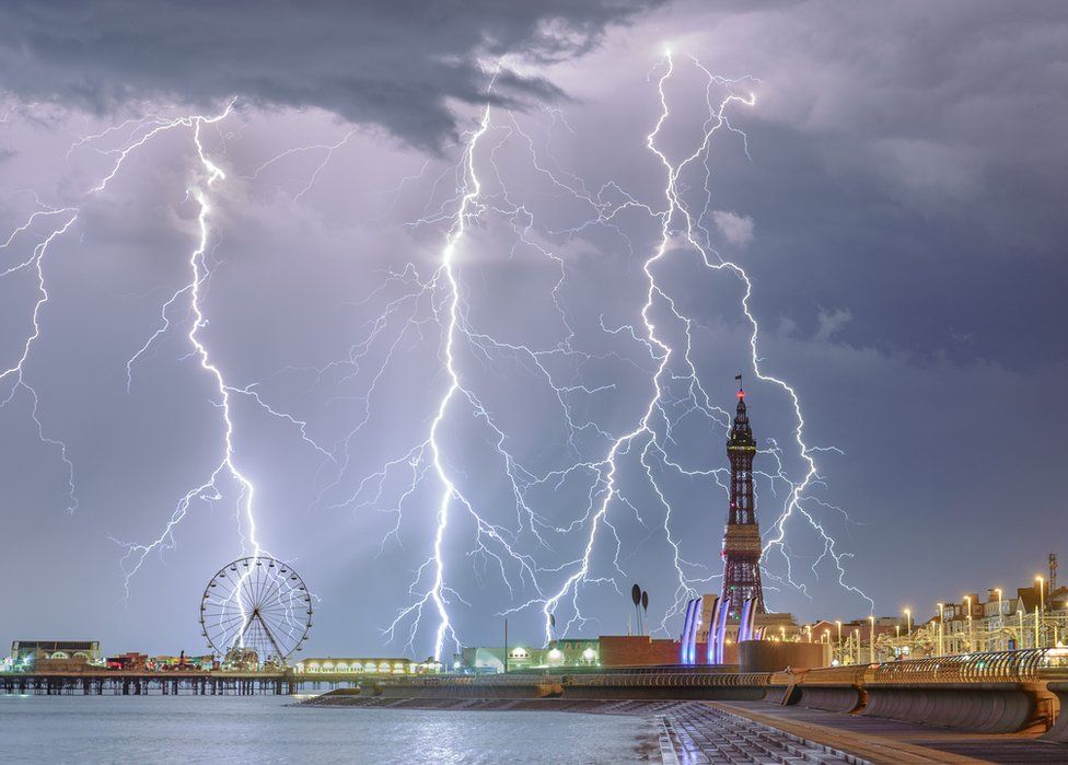
A British photographer has scooped a global prize with his shot of lightning over Blackpool.
Let us just have a little fun while we are in this new blogging series and view a side image that deserves attention, as we see thunder and lightning striking down on top of Blackpool, a beach resort in the county of Lancashire in England of the United Kingdom. This image was captured by British photographer Stephen Cheatley in the summer of 2018, and with his Electric Blackpool image, he was crowned as Weather Photographer of The Year. It certainly is a very stunning image, which deserves a mention as an honorable mention in our series and a view in this post.
“There was very strong rain and wind for about 15 minutes, at which point the rain cleared and the lightning show began” says Matthew Burke
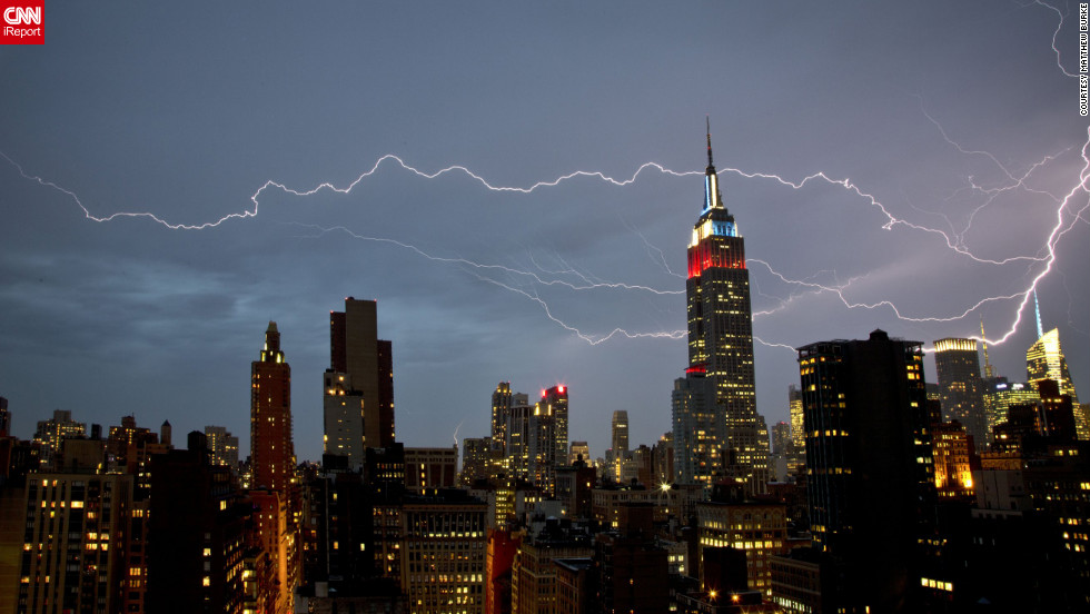
We are starting a new blogging series that will not explore maps, but images instead. We will look at images of the various different weather conditions and describe what causes them to happen. In this first image, we see thunder and lightning striking down in New York City near the Empire State Building. When a positive and negative charge grows large enough in the sky you get lightning. This giant spark of electricity surges through clouds and sometimes touches down on Earth’s surface. Thunder is the sound lightning makes, this is because lightning suddenly increases the pressure and temperature around it, expanding the air and making a thunderous boom. This dramatic lightning shot was captured by Matthew Burke from his Manhattan apartment window in July of 2012. It certainly is a very shocking scene to see in the city, which makes it the first image to be viewed in our new blog series.
Climate Change changes a region from moist green lands to dry desert.
Climate Change is a topic that everyone has heard of at some point in their lives. It is when the Earth’s climate system changes and results in new weather patterns that would last for a few decades or for millions of years. The altered weather patterns can affect a region of land and change its appearance forever. North America is no exception as it has the most weather activity happening world wide, which makes it affected by climate change the most. Concerning this topic, we will look at how climate change can affect North America in the following regions: Alaska, Canada, mainland United States, and Mexico.
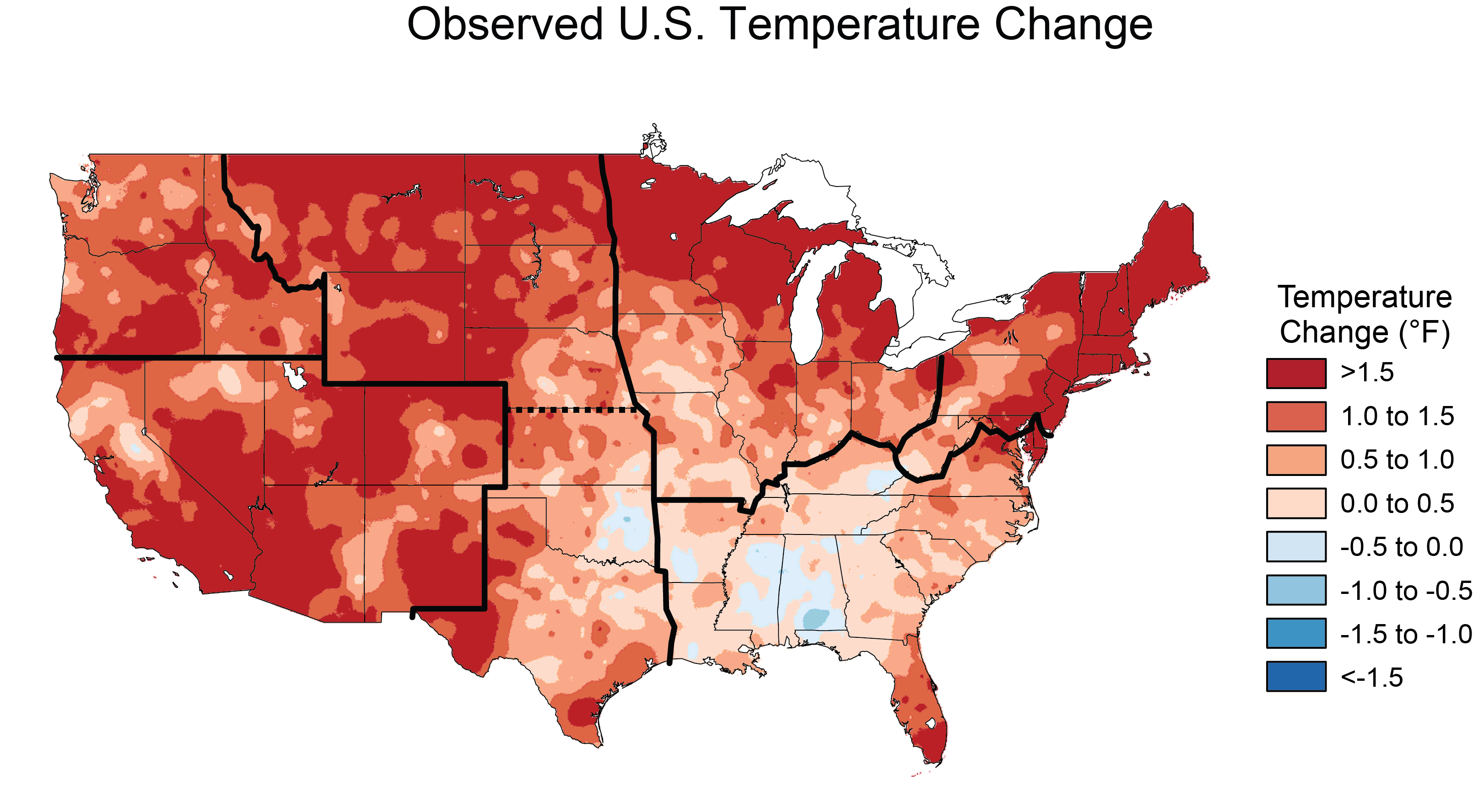
Alaska warming up over the years.
Alaska is the most northern state of the United States, and is experience climate change at some point in the future. Temperatures are increase in the region and is causing a lot of ice in that region to melt away. As the United States’ only Arctic region, Alaska is well known for its glaciers and ice. However, Alaska has also warmed twice as fast as the rest of the nation, bringing widespread impacts. Sea ice is rapidly receding and glaciers are shrinking. Thawing permafrost, or a permanently frozen layer below the Earth’s surface, is leading to more wildfire, and affecting infrastructure and wildlife habitat. Rising ocean temperatures will also affect many fishing sites in the area. All in all, Alaska is being affected by climate change more so then ever.
Canada is no different from Alaska with the risk of increasing temperatures and the melting of ice. Only Canada faces a higher rate of warming considering most of Canada is further south of the Arctic Circle than Alaska. There is already a dramatic reduction of Arctic sea ice cover, particularly in the summertime. This shrinking and melting of sea ice and glaciers will disrupt normal ocean circulation, causing sea-levels to rise and creating changes in climate and weather around the globe. There are some dangerous changes in weather and climate that is affecting Canada right now such as flooding, droughts and wildfires.
Arctic sea ice and glaciers melt away in Canada.
“In the Canadian West, wildfires rage stronger and harsher than ever before. We’ve witnessed cities and homes burning, ranchers losing their stables – and each fire season, more communities displaced by the flames,” says the Honorable Catherine McKenna MP, Canada’s minister of environment and climate change.
“On the prairies, droughts and floods occur with increasing frequency, and produce greater devastation for families and farmers whose homes and businesses are harmed.”
These changes in weather patterns are being driven in large part by ever-rising temperatures and changes in precipitation patterns. On average, Canada has become both warmer and wetter. But the amount and distribution of rain, snow, and ice across Canada has also shifted with some places getting more rain and snow fall and others getting little. All of these changes in weather patterns could affect Canada’s wildlife and environment in harmful ways and even places the risk of wildfires in the country even higher, which is why Canada faces a greater threat from climate change than other North America countries.
Canada is at risk of wildfires.
Across the United States, communities are already experiencing the impacts of climate change. Rising seas, increased droughts, more intense heatwaves and wildfires, and stronger storms threaten American cities and towns and their economies. It is no surprise increasing temperatures have become apparent in the nation every year. Days are now becoming more warmer, especially in the summertime, some areas experiencing an increase in precipitation and other areas becoming dryer. This feels like the United States faces the affects of climate change almost every day, which is why the nation is taking steps towards cleaner and more efficient energy sources in order to try and limit the effects that climate change is having on the country now.
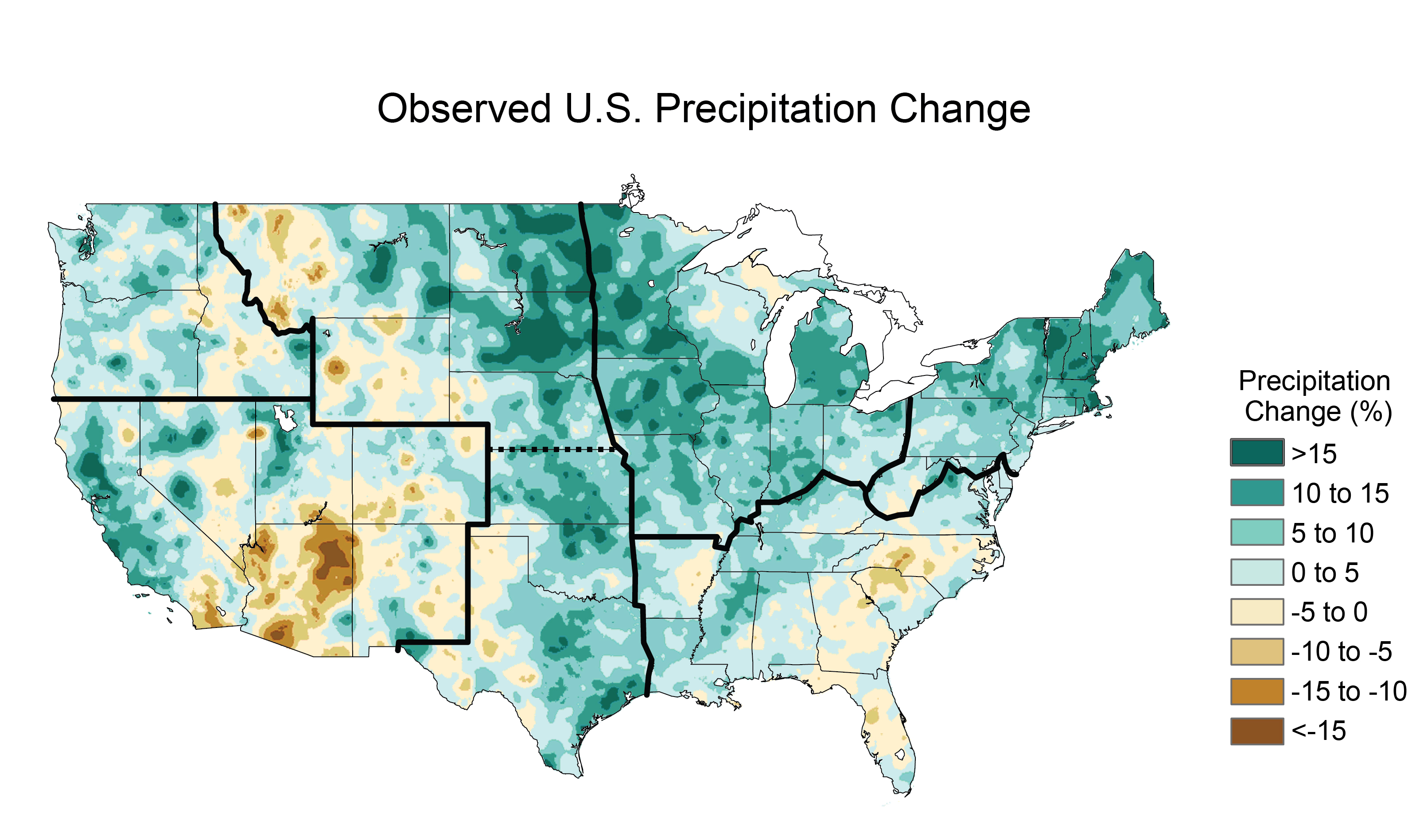
Increasing temperatures in the United States.Precipitation happens more in some areas and less in others.
The Final region of North America that will be looked into is Mexico. Mexico is very much vulnerable to the impacts of global climate change, many of which may be irreversible. These impacts include continuous sea-level rise affecting coastal areas and inland basins, an increase in the sea surface temperature in the Gulf of Mexico, intensified hurricanes, changes in the hydro logical cycle leading to increasingly heavy rains and strong storms, longer and more frequent droughts, and net decreases in water run-off. This is a reason why Mexico is very vulnerable to climate change as much as the rest of North America.
Precipitation change in Mexico, from 1950-2000 to 2021-2040. Image/data: Gabriel Vecchi, Geophysical Fluid Dynamics Laboratory, National Oceanic and Atmospheric Administration. There seems to be less precipitation that is happening in the region. A Mexican farmer works at his plot of corn in Puebla state, Mexico, in 2007. Global warming could drive millions more Mexicans into the United States in search of work by 2080 due to diminishing crop yields in Mexico, a study released Monday showed. Because of the lack of rainfall, crops are drying out.
The risk of climate change is real and could ruin a lot of the region for generations to come. North America faces a lot of these risks with increases in temperature, dryer lands and more harmful weather events than it has experienced in the past. However, people are taking steps to limit the risk of climate change, by using cleaner, more efficient energy, limit the amounts of carbon dioxide emissions occurring and using alternate fuels that are less pollutant. Climate change can be hurtful in many ways, and it is not just North America that feels the risks of it. People should be aware of the dangers and should take steps to limiting the risks that lie in what is climate change.
Place Name, also known as toponyms, is the main study of a part of geography called Toponymy. It is aimed to be devoted to the study of proper names. This is considered a study within geography, not the actual study of geography itself. Yet, People seem to misunderstand what geography means for us to study and what we should look into. We shale look into what the term place name is used for and what geography actually is to us.
Place Name itself is used every day to describe where a person is and where they want to go. Place names on maps, signs and during daily conversations help us identify historic, cultural and natural features on the landscape. Name origins may reveal histories about the people, place and their community. Although this is used to make out on what what a location is, it is not what geography fully studies, as we look into seeing what geography actually means and that it is actually more than just knowing the names of places.
Geography is actually the study of the physical features of the earth and its atmosphere, and of human activity as it affects and is affected by these, including the distribution of populations and resources and political and economic activities. This means that geography is focused on any particular study that is in relation to the study of real world phenomena’s that happen across the globe.
Now, of course teachers should teach the 50 US states and other “place name” geography information, but they need to make their students understand that there is a lot more to geography that relates to the physical properties rather than just the name of a place. People should know about the concepts of geography and how well it benefits our world by the time they graduate high school and should have the skills to identify the affects that real world phenomena’s would have on other people and the modern world, such as presenting maps, spatial data, being able to gather information from the field using a variety of techniques such as surveying, questionnaires, field sketching, measuring, photographing, interviewing and observing, etc.
For example, if one was to know the climate and natural resources of the land, they would have to be able to identify the conditions of the land that make up the climate and know the conditions and consequences of extracting these resources from the land. This would describe on how geography is suppose to work in the real world.
Geography is the study of the Earth
Geography is a unique field of science that we study everyday. It allows us to study the Earth and each other in order to better understand how the world works. This is why it is important to know geography as it is, so that we can know our world and know how to handle each other when we run into a problem that no one can solve alone. Geography is more than just the name of a place, it is the study of everything around us, and we must understand that in order to make our world a better place for everyone.
Dances with Wolves Oversees the Landscape of North America
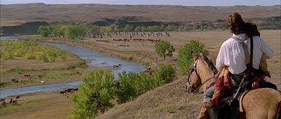
The Movie: Dances with Wolves, is an American tale that tells of an American soldier named Lieutenant John J Dunbar that goes to the western frontier in order to see what it is like before it disappears forever. Set in the midst of the American Civil War, taking place in South Dakota, it focuses on the view of an area of land that will eventually fall to western expansion by the war’s end. This film provides us with a major view of what the American landscape was like before the time expansion tool place that changed it in order for the settlers to make a living for themselves and the U.S. government began extracting the resources from the land. The movie also represents the views of the land to the Native American tribe that inhabits the land, the Sioux tribe, and what it also represents to them. We will review the Landscape side of the film and how the land is so important to the Sioux and how what they ended up going through outside of the movie.
Trailer to Dances With Wolves.
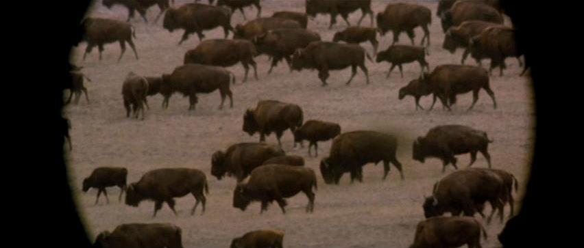
When the movie introduces us to the landscape that is the main setting, we are shown open grasslands that lie on plains of hills as far as the eye can see. This area of land was once home to millions of buffalo in which the Sioux and other Native American Tribe have hunted for food and have used for cultural purposes, such as clothing and create tools to survive with. Unfortunately, By the end of the 1800’s, their numbers were reduced to a few hundred and they almost went extinct. However, with conversation efforts to bring them back, the buffalo are returning to roam the open fields of North America with a couple thousand today. The Buffalo is still a significant animal to the Native American culture and will continue to do so as long as Native American’s stay true to what they believe in and hold on to their culture for generations to come.
‘And we’ll be back, after this 60-hour buffalo hunt!’
The landscape itself is viewed by many as vital to many people, both settlers and Natives alike. To the settlers and officials of the U.S. government, the land is a chance to expand territory, a place to settle upon to gain a new life and a source for resources to provide welfare for the country. However, to the Native Americans, the land is sacred to them, and is something they are willing to fight for. They have lived off of the land for generations and will protect it if it was threatened. In the film, we see this when the a rival tribe threatens to take the land from the Sioux and they defend it from being taken by this tribe with the help of Dunbar, whom by now has switched sides and now becomes one of them, gaining the name Dances with Wolves.
The Natives Americans have lived on this land for generations and will fight for it no matter the odds.
Towards the End of the film, however, the military from the U.S. comes along with the intent to destroy the Sioux way of life and put them in to their modern society. The Sioux, along with the main character run from them to hide with the movie ending with a note of an uncertain but likely dark future where the Sioux Indian way of life is no more.
The Western settlers and Natives fight for the land in the American-Indian war.
The film is a fiction of course, however it provides us an insight of how much the Native American way of life connects to the landscape itself and shows a prelude to a fight with Western settlers form the U.S. who wished to take the land for resources, bring society and religion to the land and settle into it to have a new life in the frontier. This came to be known a manifest destiny, the belief in the middle of the 19th century that the United States had a special mission to expand westward. Many people believed that it was inevitable for the U.S. to expand across the continent and reach all the way to the Pacific Ocean; and the Natives were to be adapted to the customs and way of life in the U.S. and be placed on reservations that marked were they were to live on and stay away from the settlers as they settle on land that once belonged to them.
It was believed in Manifest Destiny that expansion across continental North America was inevitable by the people of the U.S.
This lead the Natives to fight for their land and protect what is theirs in what came to be known as the American-Indian War. Despite having won many victories over the U.S. Army, the Natives lost and were eventually forced on to the reservations with no hope of getting their land back. Over the years, however, they kept on fighting for their land in spite of all the hardships they have to go through with the government having to take more of their land and making their reservations even smaller than before. Even today, they are still fighting for their land in protest to the government long even after the American-Indian War came to an end; especially when it came for the recent Dakota Oil Pipeline.
People in protest against the Dakota Oil Pipeline.
The Natives have spent years fighting against this pipeline that threatened to take more of their sacred land all together, and they were not alone. People form all over the world, including environmentalists, nearby residence and even veterans all came together and joined the Natives to fight this Pipeline and keep it from being built in sacred land that could threaten to damage the Missouri River and nearby water supplies that give off clean drinking water in the event of an oil spill that could severely damage the ecosystem and environment of the central United States. Unfortunately, after so much political pressure and protesting, the Pipeline was never the less approved for construction and is now currently in full operation to this day.
There is simply a lot of information to cover on this topic that cannot all be described in just one topic. For those who wish to know more detailed information on this topic and know the historical content on the film, then they should take a look at this historical film critic’s review of the film, which is a bit outdated, but goes into greater detail of the film and the events that have been discussed from above. The link to this review can be found below:
What does all of this have to do with the film? Because Dances with Wolves shows us just how much the land means to the Native American and how much it connects them to their way of life; and after all of these years, decades after the American-Indian War, they are still fighting for the land they have once roamed about freely before western expansion took it from them and defend their way of life from being destroyed for ever. It is amazing to see what these people go through and how they are still fighting for their land to this day. It is this particular reason why we should recognize the struggles the Native Americans go through, because of how they could stand up for something they know is truly right and their will to defend what has been theirs for generation. This is exactly why they are still considered, as they have always have been since the 1800’s, the true warriors of the land.
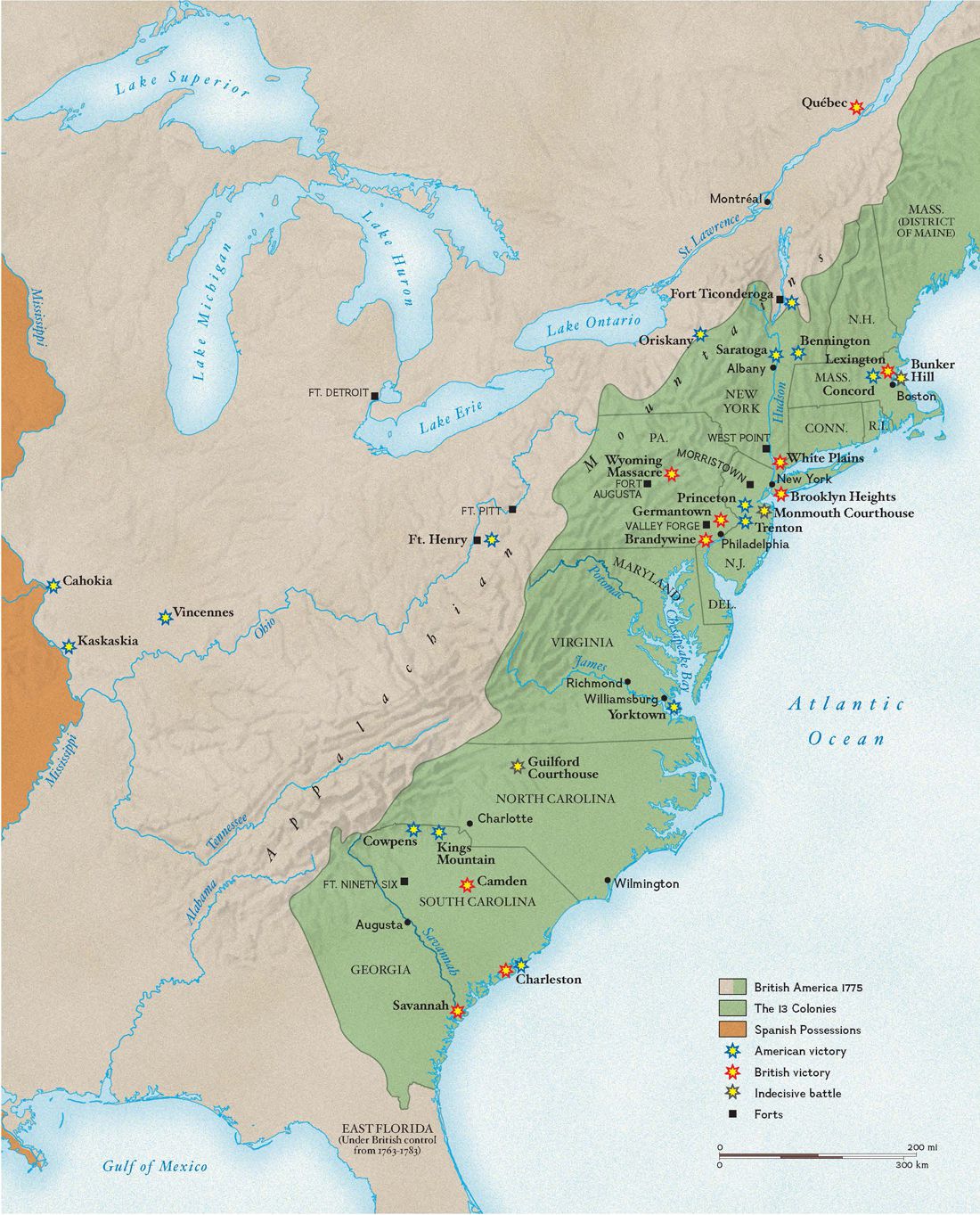
This is the last map of our series of U.S. military maps, and it is on the war that started it all for our nation, the American Revolutionary War. America’s war for independence began on April 19, 1775, when the first shots were fired at Lexington and Concord in Massachusetts, when Britain began to give off taxes without representation after the French-Indian War, denied expansion further into land gained as a result of the war, and a series incursions that began to put Colonials and Britain’s against each other. This map shows the battles that were fought, the positions of the forts used in the war, the territories of the 13 Colonies, the land occupied by the British and land that was in possession of the Spanish while the war took place. After the Battle of Yorktown in 1779, the British began negotiations to cease the hostilities and ultimately recognize the United States as a nation. Bringing the war to an end on September 3, 1783, British troops began leaving the new-born nation with the last one leaving on November 25, 1783, marking the end of British rule in the new United States and bringing forth a new nation that was destined for many great things from there on out. We end this map series with the battles of the American Revolutionary war, and will look forward on a new topic for a map series in North America.
Moving from battles to bases again in this series, we take a look at the military bases from where they currently are located in modern times. We see the bases of the Air Force and the Army all across the nation as well as a list of the bases that are over sea’s in other parts of the world. The bases shown are major bases which means that these are the forts, airfields and installations that are in major operations in the United States and are the recognizable bases in their respected states. From the earliest bases from before the Civil War, to modern times, we have seen just how much the military has expanded their bases from across the United States in the way that it has. Now we must end our looks across the military bases of the United States, and look into our last map of the series which will be on battles for the last time and this map will be on the battles of the American Revolution!
For the next map of the series, we move back to battles again and take a look at the battles fought during the war of 1812 between the British and the U.S. in the year of 1812. In this map, we see the British blockade along the east coast, movements of British and American forces, what the territories and States looked like during this time, the battles fought and the victories that were won by both sides during the war. In spite of the war itself, it ended with no winner and nothing was gained or lost in the aftermath. Still, even though the war was not that well remembered a lot, it left a legacy that made the nation stronger and gained more patriotism for the nation. It was also where Francis Scott Key wrote the poem: “The Star Spangled Banner,” while imprisoned in Baltimore on a British ship, where it later became our national anthem. The War of 1812 is definitely a piece of American history that that should not be forgotten and be remembered as a reason for Americans to believe that the nation would continue to survive and prosper well into the future.
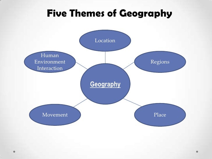
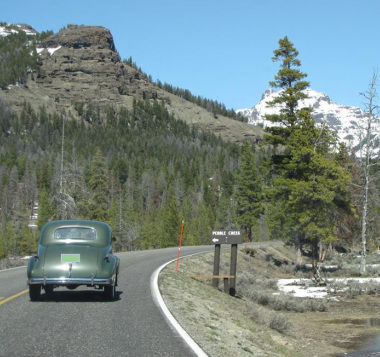
The five themes of geography are what describe the whole subject of Geography in five themes. They are Known to be location, place, human-environment interaction, movement, and region. When we are discussing the study of the physical features of the earth, including how humans affect the earth and are affected by it, these themes are what we use to describe on how Geography is used. It can be key when we wish to understand a specific area and what we would do to it. To see just how much these themes work in geography, let us look at an example of this in the flagship of the National Park Service and a favorite place to visit for to millions of visitors each year, Yellowstone National Park.
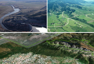
Map shows the location of Yellowstone National Park in the United States.Map of the park shows dimensions of park. The first theme is location. It is defined as a particular place or position. Most studies of geography begin with the mention of this theme of geography. Location can be of two types: absolute location and relative location. In the former case, the location of a place is defined by its latitude and longitude. When looking at Yellowstone, we would look at the absolute location of the park when we say its coordinates are 44.4280° N, 110.5885° W. However, when we say that Yellowstone is located mostly in Wyoming while partly being in Idaho and Montana, we are referring to the relative location of the park.
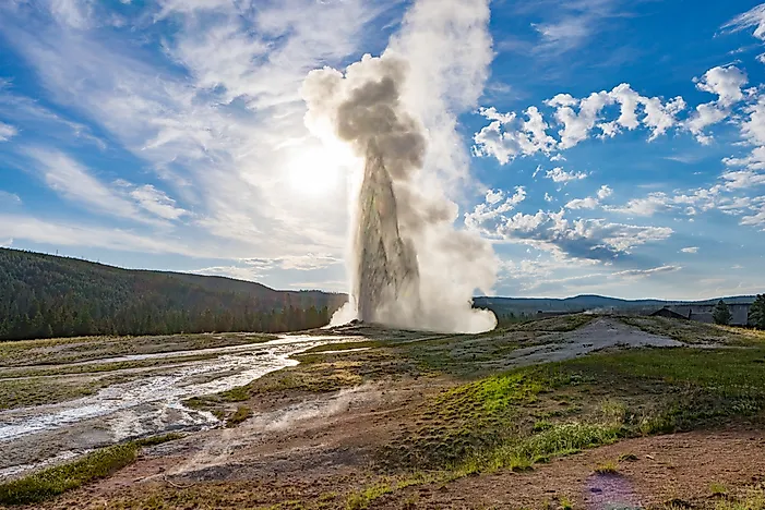
The “Old Faithful” geyser at Yellowstone National Park erupts in intervals as short as 30 minutes, and no longer than every two hours.
The next them to talk about is place. This refers to the physical and human aspects of a location. This theme of geography is associated with the name of a place (toponym), the description of the features of the place (site), and the environmental conditions of the place (situation). In Yellowstone, it is described as a geological smoking gun that illustrates how violent the Earth can be. It stands out from other national parks with the extravaganza of its geysers and hot springs, as well as the amount of wildlife that it has with its bison, elk, and bears. The reasons for the geysers and hot springs is due to most of the park rests atop a slumbering super volcano that erupted half a million years ago and is showing signs of renewed activity. Don’t worry, it is not expected to erupt in the near future.
Land use in Yellowstone. This next them focuses on human-environment interaction, as no other species that has lived on our planet, as per our knowledge to this date, has such a profound effect on the environment as humans. Humans have adapted to the environment in ways that have allowed them to dominate all other species on Earth. Humans have also achieved what no other species have been capable of doing: modifying the planet to attain their goals of living. Thus, human-environment interaction needs special emphasis and has been classified as one of the five themes of geography.Car driving through Yellowstone.
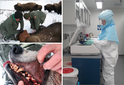
Unfortunately, human activity can have many negative effects on Yellowstone’s ecosystem. This would include a rapid spread of disease to Yellowstone’s wildlife, littering, the use of vehicles in the park that can affect air quality, burning of fossil fuels, the use of artificial fertilizers, and sewage dumping. As a result, Yellowstone could undergo a series of changes in the future due to climate change, land use, and invasive species. These factors could dramatically alter the land within the park. Currently, the climate is being monitored around the world. Biologists are taking note of the effects of climate change on ecosystems. In Yellowstone National Park, scientist focus on natural resource monitoring in order to evaluate trends in park resources and status. Land use is continually studied to gain information concerning climate change, wildfires, and management of migratory wildlife. Scientist study land use and land cover to understand past, current, and future trend that may affect resources in Yellowstone.Photo showing the effects of the disease in the grizzly bear.
Biologists studying Yellowstone have noted that human intervention in natural ecological processes may be the cause of wildlife disease and mortality. Human activity has caused many diseases to spread into Greater Yellowstone and has resulted in population declines. The most notable is the population decline of wolves and trout. Management interventions have been put in place to combat the spread of foreign disease in such intricate and delicate ecosystems.
And Yellowstone’s eruption could happen with less warning than previously thought.
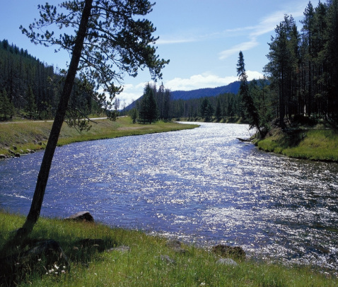
Many are concerned by the volcanic activity in Yellowstone National Park.Past eruptions have blanketed parts of North America with ash and debris. If another large eruption took place, similar events could occur. Yellowstone National Park is also home to a many active faults, which is a significant earthquake hazard.Yellowstone River
As for the immediate future, there is little evidence for alteration of the Yellowstone ecosystem. Current evidence shows that Yellowstone will continue to survive and flourish. However, we should still continue to protect our environment and allow for Yellowstone to remain intact for many years to come.Wolf in the wildlife of Yellowstone.
The Earth is full of movement and in a human-dominated planet, movement primarily refers to the translocation of human beings, their goods, and their ideas from one end of the planet to another. An example of this in our case with Yellowstone is with wolves. In 1995, Yellowstone brought the wolves back to the park. After 70 years without wolves, the reintroduction caused unanticipated change in Yellowstone’s ecosystem and even its physical geography. In a way that improved the park in the years since and made it better than it was before the wolves came back. Another example is the number of people who visit the park and interact with it in their own way. Yellowstone receives about a half-million visitors each year who move in and out of the park to witness the wonders the park provides. This is yet another example of the theme of movement in progress. Finally, we get to region. An area on the planet that is composed of places with a unifying characteristic is a region, one of the five themes of geography. A region is defined by its uniform physical or human characteristics. Yellowstone National Park is in the northwest region of the United States. The park covers 3,472 square miles and is the oldest, one of the largest, and probably the best-known national park in the United States, being established by the U.S. Congress on March 1, 1872 as the country’s first national park. Including the greatest concentration of hydro thermal features in the world, it is home to geysers, hot springs, mud pots and fumaroles bubble, gurgle, hiss and spout throughout the area. The presence of so many thermal features and earth tremors indicates that molten rock lies just beneath the Earth’s surface.
Girl looking at waterfall in Yellowstone National Park.
With all of this information, we get a very good idea on what Yellowstone National Park is like geographically. It is America’s first national park with unique water features and great wildlife that rests on a super volcano that is watched over carefully and maintained by the people who observe and protect it. Using the five themes of geography, we are able to determine that Yellowstone is all of this and is recognized as a popular attraction to many people from across the world. Geography is a very grand area of science as it helps us understand the landscape that we have come to know about. These five themes are important to understanding geography, so that we can better understand the world around us for everything that it is.
Witness the true beauty of Yellowstone National Park with a scene of Old Faithful erupting before you!
In order to understand why gentrification is an issue in North America, we must first understand what it is first. Gentrification is the process of renovating and improving a house or district so that it conforms to middle-class taste. This would mean that if an area were to change, it would be improved for the purpose of fitting the middle-class needs. However, this does have some issues to the urban and/or regional places in North America. We shale have a look at what these issues are and why it is such a big deal in North America for our exploration into human geography.
A study finds that gentrification improves Philadelphia neighborhoods, but its ripple effects hurt the most vulnerable. To its opponents, gentrification amounts to the colonization of poor, minority neighborhoods by rich people. For others, gentrification is little more than a natural process of neighborhood transformation and change. In reality, gentrification is more complex than we like to think. A study shows that gentrification ultimately hits hard at the least advantaged and most economically vulnerable. Even though the most vulnerable residents are not any more likely than others to leave gentrifying neighborhoods, when they do move they are much more likely to end up in lower-income neighborhoods with more crime and worse schools. Even if the economic disparities aren’t as severe as they may seem, a lingering complaint about gentrification is that it destroys the “soul” of a neighborhood. The gritty character, ethnic diversity and eclectic spirit that attracted the initial urban pioneers is overtaken by chain stores, overpriced brunch menus, iPad-tapping hipsters and stroller parking at the corner bar. Those are the kind of palpable social effects that can’t be quantified by statistics, but feed a growing disdain for gentrification and gentrifiers.Think Gentrification Is Bad? The Opposite Is Worse
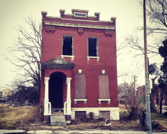
The overall phenomenon is one that’s become somewhat familiar over the past decade. Due to economic decline, lost jobs, and foreclosures, real estate in some areas of the country have declined in value so much as to be near zero. In many cases, the homes have become white elephants because the cost of maintaining the property has risen higher than what anyone is willing to pay. When that happens, owners often simply walk away. Empty houses become a magnet for squatters and drug dealers. Wild animals take up residence in the homes. The homes become fire hazards and a threat to nearby structures. The end of rent control and the addition of new developments caused gentrification to increase in neighborhoods like Cambridge’s Area Four in the 1990s. Credit: Mimi Phan
All of this in mind, it is a good reason for gentrification to be an important urban and/or regional issue in North America. Even though it intends to provide some comforts to some people, it often invites downsides to itself in terms of economics in urban areas and give hazardous structures to many regions. It is nice for people to change an area for the benefit of people with less money to live and have a living for, but in the end, it wouldn’t make a difference to many people that are already living in poverty in North America.


:max_bytes(150000):strip_icc()/American-Progress-painting-Gast-3000-3x2gty-5685a13e5f9b586a9e1e3eb0.jpg)