Carrying on with our North American maps series, we switch back no from battles to military bases again. This map shows the military camps that were used in World War 1 when America entered the war. America had not entered the war up until April 6, 1917 when a German U-Boat sank the passenger ship the Lusitania followed by the sinking of six American merchant ships with other U-Boats without warning and when the Zimmermann telegram was then intercepted, promising the Mexican Government that Germany would help Mexico recover the territory it had ceded to the United States of America following the Mexican-American War. America had declared war on Germany because of all of this, but it did not immediately join the battlefield until 1918 as they had to build up their armies first after staying neutral in the conflict since July 28, 1914. These camps were quickly created to gather up American volunteers that would become soldiers to make up that army and be trained up to be ready for the fighting that lied ahead of them in Europe that would eventually bring the war to an end on November 11, 1918.
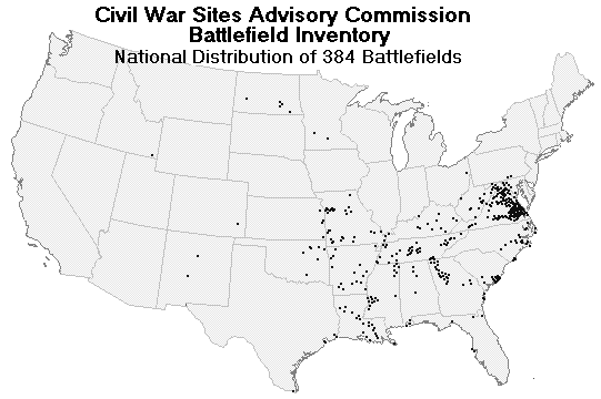
Continuing from the previous map that displayed a map of military bases before the Civil War, I have decided to continue the series with a map of the battles that were fought in the Civil War (This series will be about military maps within the U.S.). There have been many battles that have been fought in the Civil War and this map displays those battles and where they took place. Even if the battles mostly take place on the east coast, some battles took place in many places in the U.S. as well. In total, there are 384 battlefields that lie across the country in areas no one could have thought they would be in. This map shows us where those battlefields that were once fought on in the Civil War, and is just one of the maps in this series of military maps that will show other battles that were fought on American soil, and military bases that were in use during other conflicts.
If we were to take a trip across North Carolina for the purpose of find the meaning of Geography, then there are a number of things that we need to do to find what we need to find. We need to gain an idea of what to look for in the landscape itself to see how the places that we go to are different from one another. We would also would ask other geographers from the National Park Services or other natural organizations, as well as asking the locals who live in these regions, in order to understand the landscapes or each place we visit. We would also have to look for the different was on how the life around us reacts to the landscape and what defines it for what it is. With all that in mind, lets put a plan on our trip across the state of North Carolina.
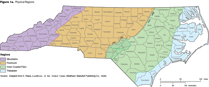
As we can see by this map, there are four physical regions of North Carolina that we would have to visit. The area that we should start at are by the beaches of the outer banks in the region of the Tidewater. Aside from seeing the sight of the houses lined up near the coast, we would go to look at the beaches first of all and work our way inland from there onward. along the way, we would be looking for the noticeable changes in the landscape, defining pieces of the landscape that defines it region it is in and asking the locals and many geographers from Natural organizations to understand the conditions and plots that make the landscape the way it is.
Moving on from there, we would move onto the areas in the inner Coastal Planes. Here, we would see that the sandy feel of the beaches would start to change to a flat lined forests for a while before reaching the Piedmont region where it starts to get a little hilly filled with forests and clear green plains. With the exception of the flatness of the Coastal Plains and the hills of the Piedmont regions, the forests and plains make both regions look the same if you count out the populated areas and cities that lie in them. However, we would then reach the last place of our trip across North Carolina: the Mountains. In this case, the Blue Ridge Mountains.
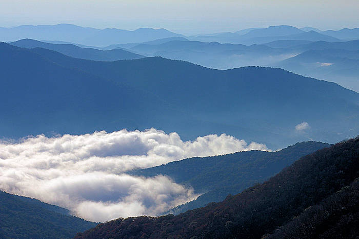
The landscape here changes greatly at the plains goes away and leaves us with a rocky and forest feel with the mountains lying high above you and giving a scene of many other mountains for as far as the eye can see. As great as seeing the ocean as far as you can see is in the Tidewater region, the Mountains are the grandest scene you could ever see in all of North Carolina. It is a truly grand skeptical that you don’t want to miss.
This trip plan is our best chance to learn of the physical geography of North Carolina, that would happen from the beaches of the Tidewater to the forests of the Mountains. We would gain a lot of information on the physical geography on all of North Carolina from looking at the landscape, taking note of our surroundings and with our many talks with the locals and geographers that we encounter in our travels. However, what would really make the trip worth the look is the scenery itself as it reminds us just how special our world can be. Let us remember that the world we live in is special and that it is worth not just looking at, but also worth protecting as well.
I will begin the first series of interesting maps that shows the geography of North America, starting within the United States. This map shows what the Military Forts and Military Districts were between the US-Mexico War and the Civil War. This would include the “Extreme Line of Outposts in 1845”, several major roads to the west, the various military departments including the Department of Texas, and a number of short lived forts west of the Mississippi. This map is linked to the website below. I have found an interest in the military of the United States a lot of the time and thus decided to start off this series with this interesting map from around the time of the American Civil War.