Moving on from lightning, we go on to the most popular weather event ever known to man in North America, especially in the United States, the tornado. Tornadoes are vertical funnels of rapidly spinning air, with winds that may top off to 250 miles an hour and can clear a pathway a mile wide and 50 miles long. These tornadoes, also known as twisters, are born in thunderstorms and are often accompanied by hail. These violent storms occur around the world, but the United States is a major hot-spot with about a thousand tornadoes every year, especially in a region that includes the area’s in the eastern states of South Dakota, Nebraska, Kansas, Oklahoma, northern Texas, and eastern Colorado being home to the most powerful and destructive of these storms. U.S. with tornadoes cause 80 deaths and more than 1,500 injuries per year. This region has come to be known as Tornado Alley.
A tornado forms when changes in wind speed and direction create a horizontal spinning effect within a storm cell, which is then tipped vertical by rising air moving up through the thunderclouds. The meteorological factors that drive tornadoes make them more likely at some times than at others. They occur more often in late afternoon, when thunderstorms are common, and are more prevalent in spring and summer. However, tornadoes can and do form at any time of the day and year. Tornadoes’ distinctive funnel clouds are actually transparent. They become visible when water droplets pulled from a storm’s moist air condense or when dust and debris are taken up.
The image above was taken by a storm chaser on November 7, 2011, America’s deadliest year for tornadoes, with more lives lost and more tornadoes happening than ever before. Yet there are some people that take a great interest in tornadoes and chase them for research, analysis and to take images of them, as well as to prepare people for them should they happen in their area. These people are known as storm chasers and they spend their time chasing tornadoes all across Tornado Alley to collect data and get shots of one. One of these storm chasers caught this image as it moved west of Manitou, Oklahoma. This stunning image of such an incredible storm gives it a place in this series and can sometimes be worth a look for many people to see.
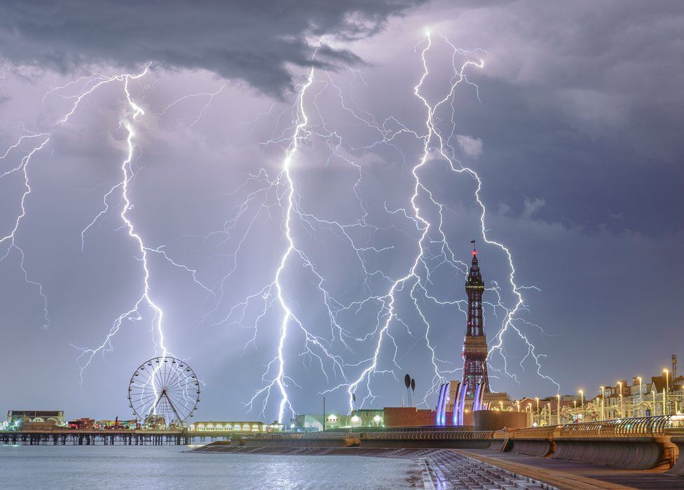
A British photographer has scooped a global prize with his shot of lightning over Blackpool.
Let us just have a little fun while we are in this new blogging series and view a side image that deserves attention, as we see thunder and lightning striking down on top of Blackpool, a beach resort in the county of Lancashire in England of the United Kingdom. This image was captured by British photographer Stephen Cheatley in the summer of 2018, and with his Electric Blackpool image, he was crowned as Weather Photographer of The Year. It certainly is a very stunning image, which deserves a mention as an honorable mention in our series and a view in this post.
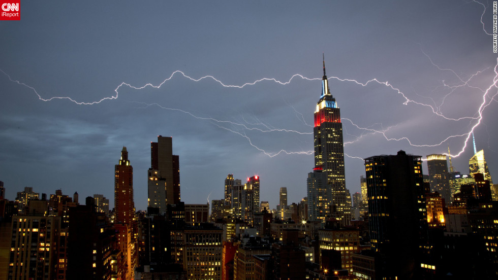
“There was very strong rain and wind for about 15 minutes, at which point the rain cleared and the lightning show began” says Matthew Burke
We are starting a new blogging series that will not explore maps, but images instead. We will look at images of the various different weather conditions and describe what causes them to happen. In this first image, we see thunder and lightning striking down in New York City near the Empire State Building. When a positive and negative charge grows large enough in the sky you get lightning. This giant spark of electricity surges through clouds and sometimes touches down on Earth’s surface. Thunder is the sound lightning makes, this is because lightning suddenly increases the pressure and temperature around it, expanding the air and making a thunderous boom. This dramatic lightning shot was captured by Matthew Burke from his Manhattan apartment window in July of 2012. It certainly is a very shocking scene to see in the city, which makes it the first image to be viewed in our new blog series.
Climate Change changes a region from moist green lands to dry desert.
Climate Change is a topic that everyone has heard of at some point in their lives. It is when the Earth’s climate system changes and results in new weather patterns that would last for a few decades or for millions of years. The altered weather patterns can affect a region of land and change its appearance forever. North America is no exception as it has the most weather activity happening world wide, which makes it affected by climate change the most. Concerning this topic, we will look at how climate change can affect North America in the following regions: Alaska, Canada, mainland United States, and Mexico.
Alaska warming up over the years.
Alaska is the most northern state of the United States, and is experience climate change at some point in the future. Temperatures are increase in the region and is causing a lot of ice in that region to melt away. As the United States’ only Arctic region, Alaska is well known for its glaciers and ice. However, Alaska has also warmed twice as fast as the rest of the nation, bringing widespread impacts. Sea ice is rapidly receding and glaciers are shrinking. Thawing permafrost, or a permanently frozen layer below the Earth’s surface, is leading to more wildfire, and affecting infrastructure and wildlife habitat. Rising ocean temperatures will also affect many fishing sites in the area. All in all, Alaska is being affected by climate change more so then ever.
Canada is no different from Alaska with the risk of increasing temperatures and the melting of ice. Only Canada faces a higher rate of warming considering most of Canada is further south of the Arctic Circle than Alaska. There is already a dramatic reduction of Arctic sea ice cover, particularly in the summertime. This shrinking and melting of sea ice and glaciers will disrupt normal ocean circulation, causing sea-levels to rise and creating changes in climate and weather around the globe. There are some dangerous changes in weather and climate that is affecting Canada right now such as flooding, droughts and wildfires.
Arctic sea ice and glaciers melt away in Canada.
“In the Canadian West, wildfires rage stronger and harsher than ever before. We’ve witnessed cities and homes burning, ranchers losing their stables – and each fire season, more communities displaced by the flames,” says the Honorable Catherine McKenna MP, Canada’s minister of environment and climate change.
“On the prairies, droughts and floods occur with increasing frequency, and produce greater devastation for families and farmers whose homes and businesses are harmed.”
These changes in weather patterns are being driven in large part by ever-rising temperatures and changes in precipitation patterns. On average, Canada has become both warmer and wetter. But the amount and distribution of rain, snow, and ice across Canada has also shifted with some places getting more rain and snow fall and others getting little. All of these changes in weather patterns could affect Canada’s wildlife and environment in harmful ways and even places the risk of wildfires in the country even higher, which is why Canada faces a greater threat from climate change than other North America countries.
Canada is at risk of wildfires.
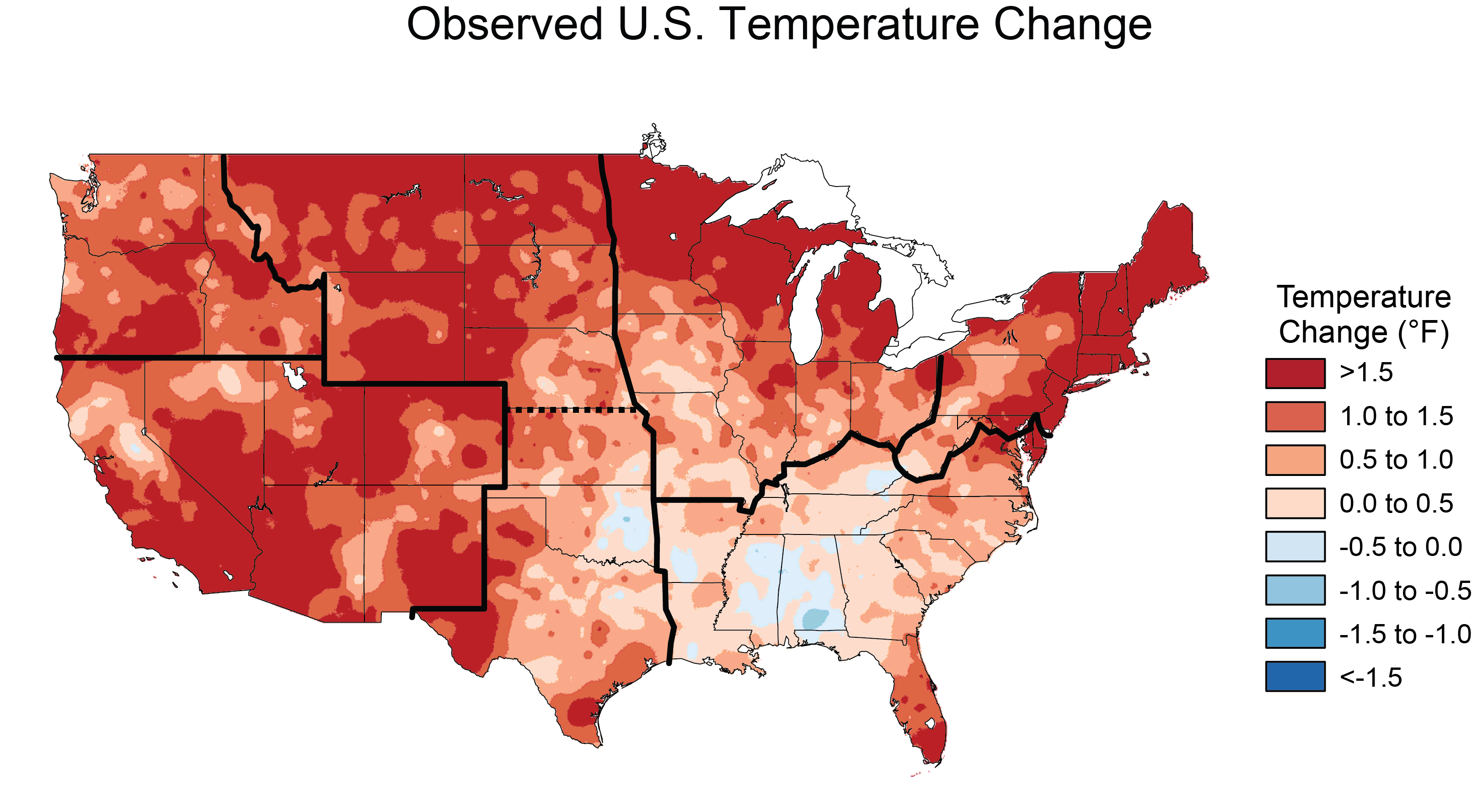
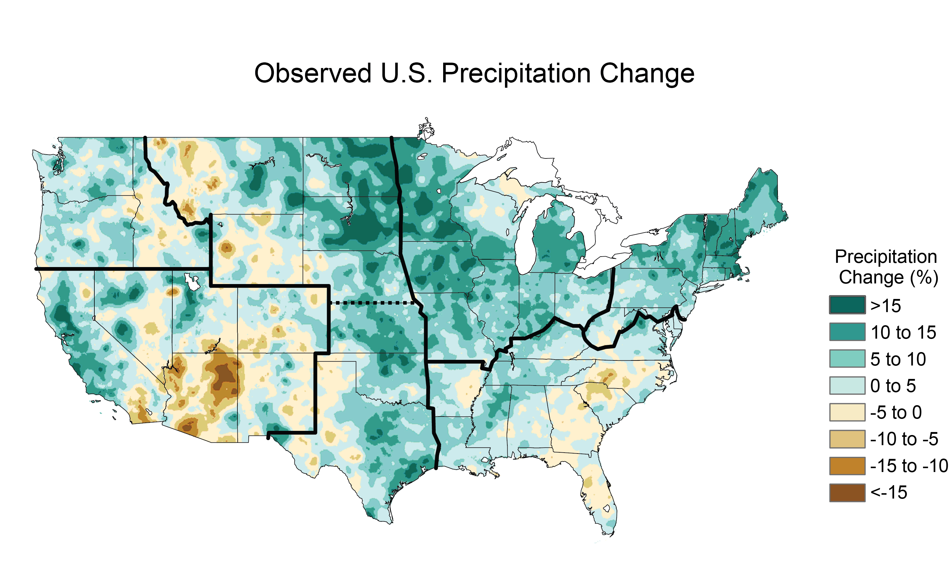
Across the United States, communities are already experiencing the impacts of climate change. Rising seas, increased droughts, more intense heatwaves and wildfires, and stronger storms threaten American cities and towns and their economies. It is no surprise increasing temperatures have become apparent in the nation every year. Days are now becoming more warmer, especially in the summertime, some areas experiencing an increase in precipitation and other areas becoming dryer. This feels like the United States faces the affects of climate change almost every day, which is why the nation is taking steps towards cleaner and more efficient energy sources in order to try and limit the effects that climate change is having on the country now.
Increasing temperatures in the United States.Precipitation happens more in some areas and less in others.
The Final region of North America that will be looked into is Mexico. Mexico is very much vulnerable to the impacts of global climate change, many of which may be irreversible. These impacts include continuous sea-level rise affecting coastal areas and inland basins, an increase in the sea surface temperature in the Gulf of Mexico, intensified hurricanes, changes in the hydro logical cycle leading to increasingly heavy rains and strong storms, longer and more frequent droughts, and net decreases in water run-off. This is a reason why Mexico is very vulnerable to climate change as much as the rest of North America.
Precipitation change in Mexico, from 1950-2000 to 2021-2040. Image/data: Gabriel Vecchi, Geophysical Fluid Dynamics Laboratory, National Oceanic and Atmospheric Administration. There seems to be less precipitation that is happening in the region. A Mexican farmer works at his plot of corn in Puebla state, Mexico, in 2007. Global warming could drive millions more Mexicans into the United States in search of work by 2080 due to diminishing crop yields in Mexico, a study released Monday showed. Because of the lack of rainfall, crops are drying out.
The risk of climate change is real and could ruin a lot of the region for generations to come. North America faces a lot of these risks with increases in temperature, dryer lands and more harmful weather events than it has experienced in the past. However, people are taking steps to limit the risk of climate change, by using cleaner, more efficient energy, limit the amounts of carbon dioxide emissions occurring and using alternate fuels that are less pollutant. Climate change can be hurtful in many ways, and it is not just North America that feels the risks of it. People should be aware of the dangers and should take steps to limiting the risks that lie in what is climate change.
Place Name, also known as toponyms, is the main study of a part of geography called Toponymy. It is aimed to be devoted to the study of proper names. This is considered a study within geography, not the actual study of geography itself. Yet, People seem to misunderstand what geography means for us to study and what we should look into. We shale look into what the term place name is used for and what geography actually is to us.
Place Name itself is used every day to describe where a person is and where they want to go. Place names on maps, signs and during daily conversations help us identify historic, cultural and natural features on the landscape. Name origins may reveal histories about the people, place and their community. Although this is used to make out on what what a location is, it is not what geography fully studies, as we look into seeing what geography actually means and that it is actually more than just knowing the names of places.
Geography is actually the study of the physical features of the earth and its atmosphere, and of human activity as it affects and is affected by these, including the distribution of populations and resources and political and economic activities. This means that geography is focused on any particular study that is in relation to the study of real world phenomena’s that happen across the globe.
Now, of course teachers should teach the 50 US states and other “place name” geography information, but they need to make their students understand that there is a lot more to geography that relates to the physical properties rather than just the name of a place. People should know about the concepts of geography and how well it benefits our world by the time they graduate high school and should have the skills to identify the affects that real world phenomena’s would have on other people and the modern world, such as presenting maps, spatial data, being able to gather information from the field using a variety of techniques such as surveying, questionnaires, field sketching, measuring, photographing, interviewing and observing, etc.
For example, if one was to know the climate and natural resources of the land, they would have to be able to identify the conditions of the land that make up the climate and know the conditions and consequences of extracting these resources from the land. This would describe on how geography is suppose to work in the real world.
Geography is the study of the Earth
Geography is a unique field of science that we study everyday. It allows us to study the Earth and each other in order to better understand how the world works. This is why it is important to know geography as it is, so that we can know our world and know how to handle each other when we run into a problem that no one can solve alone. Geography is more than just the name of a place, it is the study of everything around us, and we must understand that in order to make our world a better place for everyone.